Walk ab116 Beinn Lora from Benderloch

This 4½ mile, Grade 4 (Moderate), easy-to-follow, hand-crafted walk, complete with GPS Waypoints, starts at Benderloch & will take about 3 hrs to complete.

Download Walk PDF Icon
Download GPX Track Icon
Download GPS Waypoints Icon

Vital Statistics:

Length:4½mls (7km)
Ascent:1,241ft (378m)
Time:3hrs
Grade:Walk Grade 4_23_with_text.png Icon

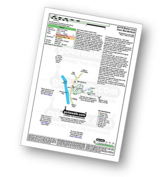
Route outline for walk ab116:

Benderloch  -  Eagles Eyrie Viewpoint  -  Beinn Lora  -  Benderloch

Peaks, Summits and Tops reached on this walk:

Munro Icon
0
Munros
Corbett Icon
0
Corbetts
Graham Icon
0
Grahams
Murdo Icon
0
Murdos
Donald Icon
0
Donalds
Marilyn Icon
1
Scottish
Marilyn
Bridget Icon
0
Bridgets

Peak Bagging Statistics for this walk:

The highest point of this walk is Beinn Lora at 308m (1011ft). Beinn Lora is classified as a Scottish Marilyn (1094th highest in Scotland, 1367th highest in the UK). The summit of Beinn Lora is marked by an Ordnance Survey Trig Point.


Free-to-access Interactive Walk Planning Maps:


1:25,000 scale OS Explorer Map (orange/yellow covers):

An Interactive Walk Planning Map for OS Explorer 359 Oban South, Kerrera & Loch Melfort is not currently available


1:50,000 scale OS Landranger Map (pink/magenta covers):

An Interactive Walk Planning Map for OS Landranger 49 Oban & East Mull is not currently available


Some Photos and Pictures from Walk ab116 Beinn Lora from Benderloch

In no particular order . . .

Ben Cruachan from Beinn Lora summit trig point

Ben Cruachan from Beinn Lora summit trig point

Photo: Linda McBryde (1)


Send us your photographs and pictures from your walks and hikes

Send them in to us as email attachments (configured for any computer) along with your name/username and where the picture was taken to:

and we shall do our best to publish them.

(Guide Resolution = 300dpi. At least = 660 pixels (wide) x 440 pixels (high).)

Facebook Logo

You can also submit photos via our Facebook Page.

NB. Please indicate where each photo was taken so we can match it to a walk route.


Do not miss our pick of the Best Walks in Britain


Can two walk together, except they be agreed - Bible: Amos 3:3
Follow go4awalk.com on Twitter Follow go4awalk.com on Facebook


Find new Friends to go walking with

Walk all 214 Wainwrights in just 59 Walks. Download GPS Waypoints - Great Walks you must not miss!

Walk The Yorkshire Three Peaks Challenge Walk - All the Latest Route Information, GPS Waypoints and Split Times to keep you on Schedule

Walk The British Three Peaks Challenge Walk - All the Latest Route Information and GPS Waypoints

See our pick of The Best Walks in The Lake District - Great Walks you must not miss!

Walk our pick of the Best Lake District Ridge Walks - Great Walks you must not miss!

Walk our pick of the Best Lake District Walks to do in the rain - Great Walks you must not miss!

Walk our pick of The Best Walks in Snowdonia - Great Walks you must not miss!

Walk our pick of The Best Ridge Walks in Wales - Walks you must not miss!

Walk our pick of The Best Walks in The Brecon Beacons - Great Walks you must not miss!

Walk our pick of The Best Walks in The Yorkshire Dales - Walks you must not miss!

Walk our pick of The Best Walks in The Peak District - Walks you must not miss!

Walk our pick of The Best Walks in The Forest of Bowland - Walks you must not miss!

Walk our pick of The Best Walks in Shropshire - Walks you must not miss!

Walk our pick of The Best Walks in Cheshire - Walks you must not miss!

Walk our pick of The Best Walks in Lancashire - Walks you must not miss!

Not sure where to walk next? Try Peak Bagging - Great Walks you must not miss!

Not sure where to walk next? Walk part of a National Trail - Great Walks you must not miss!

Walks with Downloadable and Uploadable GPS Waypoint Data

Walking Kit and Gear Tested by Walkers

Full Site Search