UK Postcode EX37 - The 30 nearest easy-to-follow, circular walk route maps to you
The thirty nearest easy-to-follow, circular walk route maps to you in UK Postcode EX37 in Walk Grade Order
The UK cities, towns and villages in Devon, England that have EX37 in their UK Postcode include:
• Atherington • Burrington • Chittlehamholt • Chittlehampton • Cobbaton • Colleton Mills • Elstone • Fishley Barton • Head Bridge • High Bickington • Hudscott • King's Nympton • Langridge • Langridgeford • Northcote Manor • Satterleigh • Umberleigh • Warkleigh •
Not familiar with the area around EX37?
See these 30 nearest walks to UK Postcode EX37 on a google map
   |
Vital Statistics:
| Length: | 8.75 miles (14 km) |
| Ascent: | 1,634ft (498m) |
| Time: | 4.75hrs |
| Grade: |  |
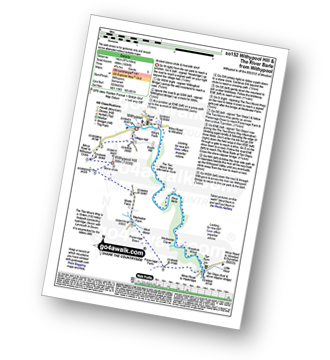
Route Summary:
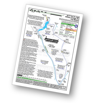
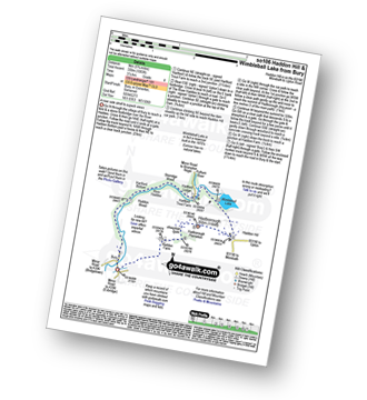
Withypool - The Two Moors Way - Withypool Hill - Westwater Farm - Parsonage Down - River Barle - Tarr Steps - Knaplock Wood - Withypool
|
Vital Statistics:
| Length: | 10.25 miles (16.5 km) |
| Ascent: | 1,664ft (507m) |
| Time: | 5½ hrs |
| Grade: |  |
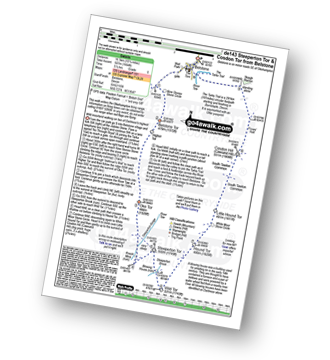
Route Summary:
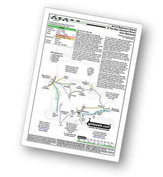
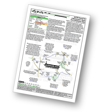
Belstone - The Tarka Trail - Nine Stones Stone Circle - Belstone Tor - Irishman's Wall - Higher Tor - Okehampton Army Firing Range - Oke Tor - The River Taw - Steeperton Tor - Steeperton Brook - Wild Tor - Hound Tor - White Moor Stone Circle - Little Hound Tor - South Tawton Common - Cosdon Hill (Cawsand Hill) - Skaigh Warren - The River Taw - Belstone
|
Vital Statistics:
| Length: | 5.75 miles (9 km) |
| Ascent: | 824ft (251m) |
| Time: | 3 hrs |
| Grade: |  |
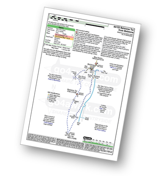
Route Summary:
Belstone - Nine Stones Stone Circle - Okehampton Army Firing Range - Belstone Tor - Higher Tor - Oke Tor - River Taw - Birchy Lake - The Tarka Trail - Belstone
|
Vital Statistics:
| Length: | 7.5 miles (12 km) |
| Ascent: | 1,141ft (348m) |
| Time: | 3½ hrs |
| Grade: |  |
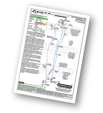
Route Summary:
Belstone - The Tarka Trail - Nine Stones Stone Circle - Belstone Tor - Higher Tor - Okehampton Army Firing Range - Oke Tor - Steeperton Tor - Steeperton Gorge - River Taw - Belstone
|
Vital Statistics:
| Length: | 7 miles (11 km) |
| Ascent: | 1,185ft (361m) |
| Time: | 3.75hrs |
| Grade: | |
Route Summary:
Belstone - The Tarka Trail - Belstone Cleave - Skaigh - Tor Down The East Okement River - Watchett Hill Cottage - Well Park - Belstone
|
Vital Statistics:
| Length: | 6 miles (9.5 km) |
| Ascent: | 1,188ft (362m) |
| Time: | 3½ hrs |
| Grade: | |
Route Summary:
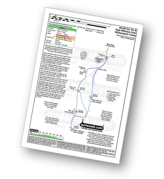
Okehampton Camp - Anthony Stile - Black Down - Red-a-ven Brook - Okehampton Army Firing Range - Yes Tor - High Willhays - West Mill Tor - Okehampton Camp
|
Vital Statistics:
| Length: | 2.75 miles (4.5 km) |
| Ascent: | 696ft (212m) |
| Time: | 2 hrs |
| Grade: |  |
|
Vital Statistics:
| Length: | 6.25 miles (10 km) |
| Ascent: | 1,621ft (494m) |
| Time: | 4 hrs |
| Grade: | |
Route Summary:
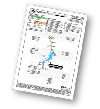
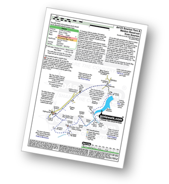
Meldon Reservoir - Longstone Hill - Okehampton Army Firing Range - Yes Tor - High Willhays - Black Tor - West Okement River - Vellake Weir - Meldon Reservoir
|
Vital Statistics:
| Length: | 9.5 miles (15 km) |
| Ascent: | 1,687ft (514m) |
| Time: | 5 hrs |
| Grade: | |
Route Summary:
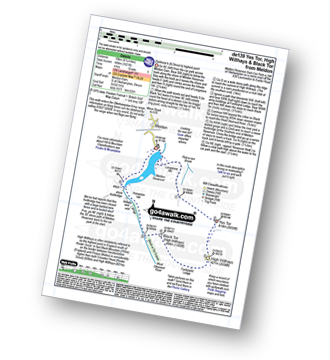
Meldon Reservoir - Longstone Hill - Yes Tor - High Willhays - Dinger Tor - Brim Beck - Kneeset Nose - Sandy Ford - West Okement River - Black-a-Tor Copse - Vellake Weir - Meldon Reservoir
|
Vital Statistics:
| Length: | 5.5 miles (8.5 km) |
| Ascent: | 1,493ft (455m) |
| Time: | 3½ hrs |
| Grade: | |
Route Summary:
Lynton - The Danes Or Valley Of Rocks - Six Acre Wood - The South West Coast Path - Lee Bay - Lee Abbey - Castle Rock - Rugged Jack - Wringcliff Bay - Ruddy Ball - Lynmouth - Lynton
|
Vital Statistics:
| Length: | 5 miles (8 km) |
| Ascent: | 1,708ft (521m) |
| Time: | 3.75hrs |
| Grade: | |
Route Summary:
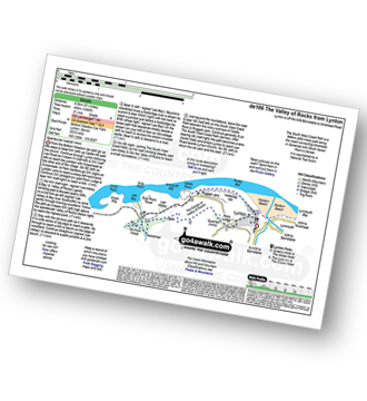
Lynmouth - The East Lyn River - Wester Wood - Horner's Neck Wood - Watersmeet - Watersmeet House - Trilly - Countisbury - Butter Hill - The Sought West Coast Path - Lower Blackhead - Sillery Sands - Black Rocks - Point Perilous - Lynmouth
|
Vital Statistics:
| Length: | 6.75 miles (11 km) |
| Ascent: | 1,208ft (368m) |
| Time: | 3.75hrs |
| Grade: | |
Route Summary:
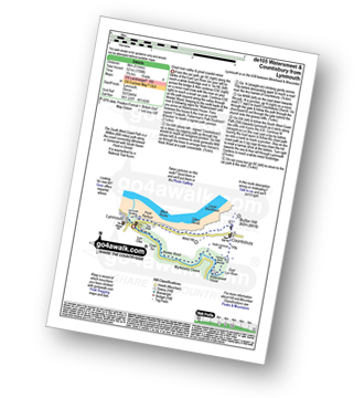
Shobrooke - Shobrook Lake - Coombe Barton - Stockleigh Wood - Parsonage Copse - Stockleigh Pomeroy - Stong's Brake - Raddon Hills - Raddon Court - West Raddon - Exeter Hill Cross - Shobrooke
|
Vital Statistics:
| Length: | 5.75 miles (9 km) |
| Ascent: | 1,083ft (330m) |
| Time: | 3.25hrs |
| Grade: | |
Route Summary:
Bury - River Haddeo - Hartford Bottom - Hartford Lodge - Pulham River - Upton Dam - Wimbleball Lake - Haddon Hill - Hadborough (Haddon Hill) - Hadborough Plantation - Haddon Farm - Bury
|
Vital Statistics:
| Length: | 9.5 miles (15.5 km) |
| Ascent: | 1,638ft (499m) |
| Time: | 5.25hrs |
| Grade: | |
Route Summary:
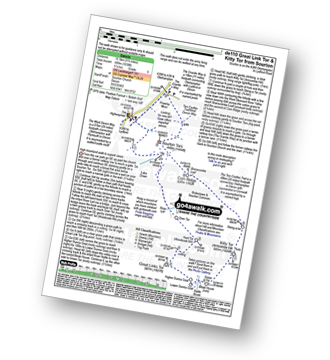
Sourton - Sourton Church - River Lyd - Gren Tor - Hunt Tor - Woodcock Hill - Great Links Tor - Higher Dunna Goat - Lower Dunna Goat - Rattle Brook - Green Tor - Kitty Tor (Amicombe Hill) - Amicombe Hill - Steng-a-tor - Corn Ridge - Branscombe Loaf - Sourton Tors - Two Castles Trail - The West Devon Way - Prewley Moor - The Granite Way - Sourton Church.
|
Vital Statistics:
| Length: | 8.25 miles (13 km) |
| Ascent: | 1,375ft (419m) |
| Time: | 4½ hrs |
| Grade: | |
Route Summary:
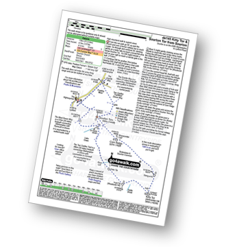
Sourton - Sourton Church - River Lyd - Gren Tor - Hunt Tor - Woodcock Hill - Rattle Brook - Kitty Tor (Amicombe Hill) - Amicombe Hill - Sten-a-tor - Corn Ridge - Sourton Tors - Two Castles Trail - The West Devon Way - Prewley Moor - The Granite Way - Sourton Church.
Not familiar with the area around EX37?
See these 30 nearest walks to UK Postcode EX37 on a google map
|
Vital Statistics:
| Length: | 6.5 miles (10.5 km) |
| Ascent: | 1,188ft (362m) |
| Time: | 3.75hrs |
| Grade: | |
Route Summary:
Sourton - Sourton Church - Two Castles Trail - The West Devon Way - Sourton Tors - Vellake Brook - West Okement River - Vellake Weir - Meldon Reservoir - Downside - The Granite Way - Prewley Moor - Sourton Church.
|
Vital Statistics:
| Length: | 5.25 miles (8.5 km) |
| Ascent: | 912ft (278m) |
| Time: | 3 hrs |
| Grade: | |
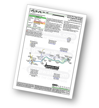
Route Summary:
Dogmarsh Bridge - The River Teign - The Teign Gorge - Sharp Tor - Fingle Bridge - Drewston Wood - Drewston Common - Hunting Gate - Piddletown Common - Castle Drogo - Hunter's Tor - Coombe - The River Teign - Dogmarsh Bridge
|
Vital Statistics:
| Length: | 6.75 miles (11 km) |
| Ascent: | 1,254ft (382m) |
| Time: | 3.75hrs |
| Grade: | |
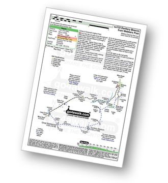
Route Summary:
Webbers Post - Dicky's Path - Hollow Combe - Dunkery Beacon - Little Rowbarrow - Great Rowbarrow - Lang Combe Head - Cloutsham Gate - Cloutsham Farm - East Water Valley - Webbers Post
|
Vital Statistics:
| Length: | 9.5 miles (15 km) |
| Ascent: | 2,038ft (621m) |
| Time: | 5½ hrs |
| Grade: | |
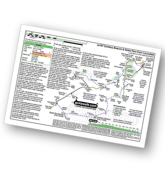
Route Summary:
Luccombe - Luccombe Plantation - Webbers Post - Dicky's Path - Hollow Combe - Dunkery Beacon - Little Rowbarrow - Great Rowbarrow - Lang Combe Head - Cloutsham Gate - Stoke Pero Church - Prickslade - Cloutsham Farm - East Water Valley - Webbers Post - Horner Plantataion - Luccombe
|
Vital Statistics:
| Length: | 6 miles (9.5 km) |
| Ascent: | 1,408ft (429m) |
| Time: | 3½ hrs |
| Grade: | |
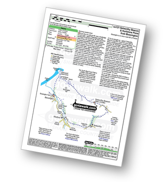
Route Summary:
Bossington - Allerford - Selworthy - Selworthy Beacon - The South West Coast Path - Hurlstone Combe - Hurlstone Point - Porlock Bay - Bossington
|
Vital Statistics:
| Length: | 9 miles (14.5 km) |
| Ascent: | 1,398ft (426m) |
| Time: | 4.75hrs |
| Grade: | |
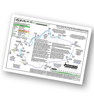
Route Summary:
Lanehead Car Park - Higher Willsworthy - Crouster Farm - Merrivale Army Firing Range - Lynch Tor - Oakhampton Army Firing Range - Fur Tor - Amicombe Brook - Watern Oke - River Tavy - Tavy Cleave - Wilsworthy Army Firing Range - Mine Leat - Nattor Farm - Lanehead Car Park.
|
Vital Statistics:
| Length: | 4.5 miles (7 km) |
| Ascent: | 870ft (265m) |
| Time: | 2½ hrs |
| Grade: | |
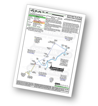
Route Summary:
Lanehead - Ger Tor - Willsworthy Army Firing Range - Hare Tor - Rattle Brook - River Tavy - Watern Oke - Tavy Cleave - Mine Leat - Nattor Farm - Lanehead
|
Vital Statistics:
| Length: | 9.75 miles (15.5 km) |
| Ascent: | 1,457ft (444m) |
| Time: | 5 hrs |
| Grade: | |
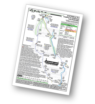
Route Summary:
Postbridge - Bellever Tor - Laughter Tor - Huccaby Tor - Dartmeet - West Dart River - East Dart River - Walla Brook - Bellever - Postbridge
|
Vital Statistics:
| Length: | 5.25 miles (8.5 km) |
| Ascent: | 821ft (250m) |
| Time: | 2.75hrs |
| Grade: | |
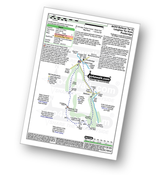
Route Summary:
Postbridge - East Dart River - Bellever Tor - Laughter Tor - Laughter Hole Farm - Bellever - Postbridge
|
Vital Statistics:
| Length: | 6.25 miles (10 km) |
| Ascent: | 1,132ft (345m) |
| Time: | 3½ hrs |
| Grade: | |
Route Summary:
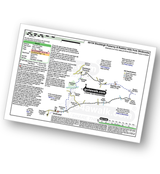
Swallerton Gate - Hound Tor (Bonehill Down) - Hundaford Village - Greator Rocks - Becka Brook - Leighton Farm - Beckaford Bridge - New Bridge - Water - Hayne Cross - Hayne Down - Bowerman's Nose - Swine Down - Jay's Grave - Moorhayes Farm - Swallerton Gate
|
Vital Statistics:
| Length: | 5 miles (8 km) |
| Ascent: | 794ft (242m) |
| Time: | 2.77hrs |
| Grade: | |
Route Summary:
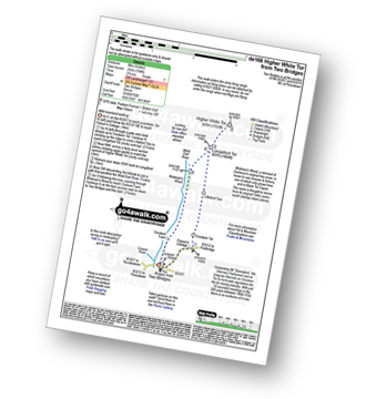
Two Bridges - Parson's Cottage - Crockern Tor - Littaford Tors - Longaford Tor - Higher White Tor - Wistman's Wood - West Dart River - Two Bridges
|
Vital Statistics:
| Length: | 8.25 miles (13 km) |
| Ascent: | 1,201ft (366m) |
| Time: | 4.25hrs |
| Grade: | |

Route Summary:
Two Bridges - Beardown Farm - Devonport Leat - Beardown Tors - West Dart River - Mothern Brook - Merrivale Army Firing Range - Devil's Tor - Cowsic River - Two Bridges
|
Vital Statistics:
| Length: | 8.25 miles (13 km) |
| Ascent: | 1,027ft (313m) |
| Time: | 4 hrs |
| Grade: | |
Route Summary:
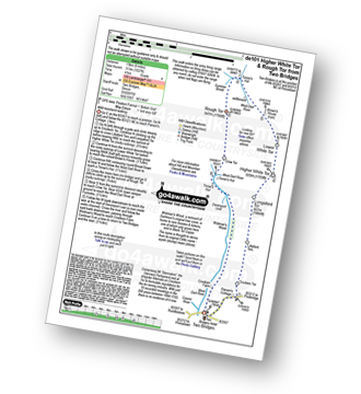
Two Bridges - Parson's Cottage - Crockern Tor - Littaford Tors - Longaford Tor - Higher White Tor - Lower White Tor - Brown's House - West Dart River - Rough Tor - West Dart River - Cockern Farm - Two Bridges
|
Vital Statistics:
| Length: | 5 miles (8 km) |
| Ascent: | 748ft (228m) |
| Time: | 2.75hrs |
| Grade: | |
Route Summary:
Merrivale - Little Mis Tor - Great Mis Tor - Merrivale Army Firing Range - Greena Ball - River Walkham - Blowing House - Merrivale
|
Vital Statistics:
| Length: | 6.25 miles (10 km) |
| Ascent: | 1,139ft (347m) |
| Time: | 3½ hrs |
| Grade: | |
Route Summary:
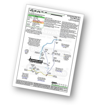
Merrivale - Little Mis Tor - Great Mis Tor - Merrivale Army Firing Range - Greena Ball - River Walkham - Langstone Moor Stone Circle - Petertravy Great Common - Roos Tor - Great Staple Tor - Middle Staple Tor - Grimstone and Sortridge Leat - River Walkham - Merrivale
Not familiar with the area around EX37?
See these 30 nearest walks to UK Postcode EX37 on a google map


