UK Postcode CA10 - The 30 nearest easy-to-follow, circular walk route maps to you
The thirty nearest easy-to-follow, circular walk route maps to you in UK Postcode CA10 in Walk Grade Order
The UK cities, towns and villages in Cumbria, England that have CA10 in their UK Postcode include:
• Askham • Bampton • Blencarn • Brougham • Cliburn • Clifton • Crosby Ravensworth • Culgaith • Eamont Bridge • Gamblesby • Glassonby • Great Strickland • Greenholme • Hackthorpe • Haresceugh • Hartsop • Helton • Hunsonby • Keld • Kelleth • Kings Meaburn • Kirkby Thore • Kirkland • Kirkoswald • Langwathby • Lazonby • Little Salkeld • Little Strickland • Lowther • Maulds Meaburn • Melkinthorpe • Melmerby • Milburn • Morland • Newbiggin • Newby • Orton • Ousby • Pooley Bridge • Raisbeck • Reagill • Renwick • Rosgill • Sandwick • Scale Houses • Shap • Skirwith • Sleagill • Staffield • Tebay • Temple Sowerby • Tirril • Whale • Wickerslack • Winskill •
Not familiar with the area around CA10?
See these 30 nearest walks to UK Postcode CA10 on a google map
   |
Vital Statistics:
| Length: | 11.25 miles (18 km) |
| Ascent: | 2,206ft (672m) |
| Time: | 6.25hrs |
| Grade: |  |

Route Summary:
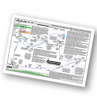
Dufton - Eller Beck - Pusgill House - Great Rundale Beck - Bluethwaite Hill - Threlkeld Side - Brownber Hill - Tossgill Edge - Great Rundale Tarn - Backstone Edge (Dufton Fell) - Narrowgate Beacon - Little Rundale Beck - High Cup Nick - High Cup - The Pennine Way - Narrow Gate Path - Peeping Hill - Bow Hall - Town Head - Dufton
|
Vital Statistics:
| Length: | 4.75 miles (7.5 km) |
| Ascent: | 1,139ft (347m) |
| Time: | 3 hrs |
| Grade: |  |

Route Summary:
Dufton - The Pennine Way - Eller Beck - Coastsyke Farm (Coatsike Farm) - Hurning Lane - Halsteads - Cosca Hill - Great Rundale Beck - Dufton Pike - Pusgill House - Dufton
|
Vital Statistics:
| Length: | 12.75 miles (20.5 km) |
| Ascent: | 2,819ft (859m) |
| Time: | 7½ hrs |
| Grade: |  |
Route Summary:
Dufton - The Pennine Way - Eller Beck - Coastsyke Farm (Coatsike Farm) - Hurning Lane - Halsteads - Cosca Hill - Great Rundale Beck - Dufton Pike - Bluethwaite Hill - Threlkeld Side - Brownber Hill - Tossgill Edge - Great Rundale Tarn - Backstone Edge (Dufton Fell) - Narrowgate Beacon - Little Rundale Beck - High Cup Nick - High Cup - The Pennine Way - Narrow Gate Path - Peeping Hill - Bow Hall - Town Head - Dufton
|
Vital Statistics:
| Length: | 5 miles (8 km) |
| Ascent: | 703ft (214m) |
| Time: | 2½ hrs |
| Grade: |  |

Route Summary:
Dufton - The Pennine Way - Eller Beck - Church Bridge - Knock Church - Swindale Beck - Knock - Cosca Hill - Great Rundale Beck - Pisgill House - Dufton
|
Vital Statistics:
| Length: | 10.75 miles (17 km) |
| Ascent: | 1,976ft (602m) |
| Time: | 6 hrs |
| Grade: | |

Route Summary:
Dufton - The Pennine Way - Town End - Kemplar Bridge - Greenhow Farm - Keisley House - Harbour Flatt Farm - Trundale Gill - Middle Tongue - Murton Fell - Murton Herds - High Cup - High Cup Gill - High Cup Nick - The Pennine Way - Narrow Gate Path - Peeping Hill - Bow Hall - Town Head - Dufton
|
Vital Statistics:
| Length: | 11.25 miles (18 km) |
| Ascent: | 2,629ft (801m) |
| Time: | 6.75hrs |
| Grade: | |

Route Summary:
Dufton - The Pennine Way - Coatsyke Farm (Coatsike Farm) - Halsteads - Great Rundale Beck - Cosca Hill - Swindale Beck - Knock Old Man - Knock Fell - Green Castle - Knock Ore Gill - Knock Pike - Swindale Beck - Knock Village - Knock Church - Dufton
|
Vital Statistics:
| Length: | 10.75 miles (17 km) |
| Ascent: | 2,437ft (743m) |
| Time: | 6 hrs |
| Grade: | |

Route Summary:
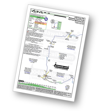
Kirkland - Kirkland Beck - Cocklick Scar - Plylier's Gap - High Cap - Ironwell Band - The Pennine Way - Cross Fell - Crowdundle Head - Tees Head - Sturba Nook - Wildboar Scar - Grumply Hill - Littledale Beck - Cringle Moor - Blencarn - Blencarn Lake - Blencarn Beck - Kirk Hill - Kirkland
|
Vital Statistics:
| Length: | 11 miles (17.5 km) |
| Ascent: | 2,288ft (697m) |
| Time: | 6.25hrs |
| Grade: | |
Route Summary:
Melmerby - Meikle Awfell - Cuns Fell - Maiden Way (Roman Road) - Meg's Cairn - Melmerby Fell - Knapside Hill - Little Knapside Hill - Fiend's Fell - Twotop Bridge - Hazel Rigg Farm - Gamblesby - Gill Beck - Melmerby
|
Vital Statistics:
| Length: | 8.5 miles (13.5 km) |
| Ascent: | 1,994ft (608m) |
| Time: | 5 hrs |
| Grade: | |

Route Summary:
Howtown - Lock Bank - White Knott - Barton Fell - Whinny Crag - Arthur's Pike - Loadpot Hill - Bonscale Pike - Swarthbeck Gill - Howtown
|
Vital Statistics:
| Length: | 5 miles (8 km) |
| Ascent: | 912ft (278m) |
| Time: | 2.75hrs |
| Grade: | |
Route Summary:
Howtown - The Coombs - St Peter's Church - Lanty Tarn - Martindale - Christy Bridge - Howegrain Beck - Sandwick Beck - Sandwick - Hallinhag Wood - Geordie's Crag - Waternook - Howtown
|
Vital Statistics:
| Length: | 4.75 miles (7.5 km) |
| Ascent: | 1,292ft (394m) |
| Time: | 3 hrs |
| Grade: | |
Route Summary:
Howtown - St Peter's Church - Hallin Fell - Geordie's Crag - Hallinhag Wood - Sandwick - Sandwick Beck - Howtown
|
Vital Statistics:
| Length: | 7.5 miles (12 km) |
| Ascent: | 2,283ft (696m) |
| Time: | 5.25hrs |
| Grade: | |

Route Summary:
Howtown - Steel Knotts (Pikeawassa) - Brownthwaite Crag - Keasgill Head - Wether Hill (South Top) - Wether Hill - Loadpot Hill - Bonscale Pike - Bonscale Tower - Swarthbeck Gill - Howtown
|
Vital Statistics:
| Length: | 1.5 miles (2.5 km) |
| Ascent: | 705ft (215m) |
| Time: | 1½ hrs |
| Grade: |  |
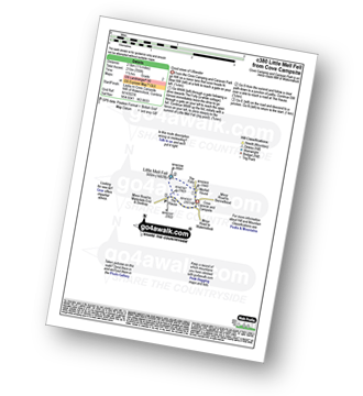
Route Summary:
Cove Park Campsite - Watermillock - Mellfell House - Little Mell Fell - The Hause - Cove Campsite - Watermillock.
|
Vital Statistics:
| Length: | 11.25 miles (18 km) |
| Ascent: | 2,736ft (834m) |
| Time: | 6.75hrs |
| Grade: | |

Route Summary:
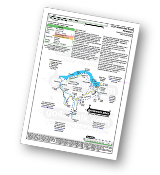
St Peter's Church (Martindale) - Howtown - Swarthbeck Gill - White Knott - Barton Fell - Whinny Crag - Arthur's Pike - Swarth Beck - Bonscale Tower - Bonscale Pike - Loadpot Hill - Wether Hill - Wether Hill (South Top) - Keasgill Head - Steel Knotts (Pikeawassa) - Steel End - St Peter's Church (Martindale) - Howtown
|
Vital Statistics:
| Length: | 14.5 miles (23 km) |
| Ascent: | 4,555ft (1,388m) |
| Time: | 9.75hrs |
| Grade: |  |

Route Summary:
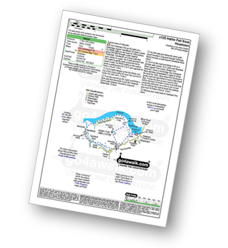
St Peter's Church (Martindale) - Howtown - Steel Knotts (Pikeawassa) - Keasgill Head - High Raise (Mardale) - Kidsty Pike - Rampsgill Head - The Knott - Rest Dodd - The Nab - Satura Crag - Brock Crags - Angle Tarn (Martindale) - Angletarn Pikes - Bedafel Knott - Beda Head (Beda Fell) - Winter Crag - Christy Bridge - Howegrain Beck - Martindale - St Peter's Church (Martindale) - Howtown
Not familiar with the area around CA10?
See these 30 nearest walks to UK Postcode CA10 on a google map
|
Vital Statistics:
| Length: | 9.75 miles (15.5 km) |
| Ascent: | 3,470ft (1,058m) |
| Time: | 7 hrs |
| Grade: | |
Route Summary:
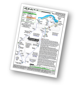
St Peter's Church (Martindale) - Howtown - Howegrain Beck - Christy Bridge - Beda Head (Beda Fell) - Martindale Common - Angletarn Pikes - Angle Tarn (Martindale) - Boredale Hause - Steel Edge - Place Fell - High Dodd (Sleet Fell) - Sandwick - Hallinhag Wood - Geordies Crag - Hallin Fell (Martindale) - Howtown
|
Vital Statistics:
| Length: | 15.75 miles (25 km) |
| Ascent: | 2,918ft (889m) |
| Time: | 8.75hrs |
| Grade: |  |

Route Summary:
Hilton Town Head - Hilton Beck - Warcop Training Area - Swindale Brow - Swindale Beck - Swindale Edge - Marn Gill - Christy Bank - Siss Gill - Burton Fell - Little Fell (Burton Fell) - Hilton Fell - Arnside Rake - King's Pot - Mickle Fell - Fisher Sike - Maize Beck - Swarth Beck - Master Sike - Murton Fell - Murton Fell (SE Top) - Scordale - Lowfield Hush - Hilton Town Head
|
Vital Statistics:
| Length: | 12.5 miles (20 km) |
| Ascent: | 3,769ft (1,149m) |
| Time: | 8½ hrs |
| Grade: | |

Route Summary:
Christy Bridge - Martindale - Dale Head Farm - Heck Crag - Angle Tarn - Buck Crag - Brock Crags - Satura Crag - The Nab (Martindale) - Rest Dodd - The Knott - Rampsgill Head - Kidsty Pike - High Raise (Mardale) - Red Crag - Keasgill Head - Christy Bridge
|
Vital Statistics:
| Length: | 12.25 miles (19.5 km) |
| Ascent: | 3,254ft (992m) |
| Time: | 7½ hrs |
| Grade: | |

Route Summary:
Brownrigg Farm - Great Mell Fell - Greenrow Great Barn - Lowthwaite - Little Mell Fell - The Hause - Underwood - Cove Park Campsite - Watermillock - Priest's Crag - Great Meldrum - Gowbarrow Fell (Airy Crag) - Norman Crag - Ulcat Row - Matterdale End - Brownrigg Farm
|
Vital Statistics:
| Length: | 3 miles (5 km) |
| Ascent: | 1,145ft (349m) |
| Time: | 2½ hrs |
| Grade: | |

|
Vital Statistics:
| Length: | 6 miles (9.5 km) |
| Ascent: | 2,202ft (671m) |
| Time: | 4½ hrs |
| Grade: |  |

Route Summary:
Mardale Head - Haweswater Reservoir - The Rigg - Swine Crag (Riggindale) - Heron Crag (Riggindale) - Eagle Crag (Riggindale) - Rough Crag (Riggindale) - Caspel Gate - Riggindale Crag - Long Stile - High Street - Rough Crag (Riggindale) - Eagle Crag (Riggindale) - Heron Crag (Riggindale) - Swine Crag (Riggindale) - Dudderwick - The Rigg - Mardale Head
|
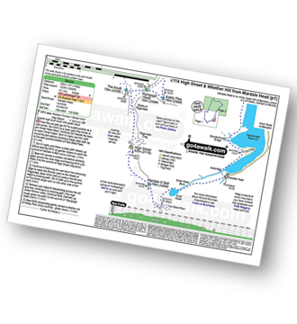
Vital Statistics:
| Length: | 11.25 miles (18 km) |
| Ascent: | 3,436ft (1,047m) |
| Time: | 7½ hrs |
| Grade: | |

Route Summary:
Mardale Head - Haweswater Reservoir - Rowantreethwaite Beck - Old Corpse Road - Selside Pike - Branstree (North East Top) - Branstree (Artlecrag Pike) - Gatescarth Pass - Adam Seat - Harter Fell (Mardale) - Nan Bield Pass - Mardale Ill Bell - High Street - Riggindale Crag - Caspel Gate - Rough Crag (Riggindale) - Eagle Crag (Riggindale) - Heron Crag (Riggindale) - Swine Crag (Riggindale) - Dudderwick - The Rigg - Mardale Head
|
Vital Statistics:
| Length: | 14.5 miles (23 km) |
| Ascent: | 3,364ft (1,025m) |
| Time: | 8½ hrs |
| Grade: | |
Route Summary:
Mardale Head (Haweswater Reservoir) - Small Water - Nan Bield Pass - Mardale Ill Bell - High Street - Straits of Riggindale - The Knott - Rampsgill Head - Kidsty Pike - High Raise (Mardale) - Raven Howe - Red Crag - Keasgill Head - Wether Hill (South Top) - Wether Hill - Bampton Common - Low Kop - Measand Beck - Haweswater Reservoir - Wainwright's Coast to Coast Walk - Bowderthwaite Bridge - The Rigg - Mardale Head
|
Vital Statistics:
| Length: | 12.5 miles (20 km) |
| Ascent: | 3,814ft (1,162m) |
| Time: | 8½ hrs |
| Grade: | |

Route Summary:
Mardale Head - Haweswater - Rowantreethwaite Beck - Old Corpse Road - Selside Pike - Branstree (North East Top) - Branstree (Artlecrag Pike) - Gatescarth Pass - Adam Seat - Harter Fell (Mardale) - Nan Bield Pass - Mardale Ill Bell - High Street - Riggindale - Rampsgill Head - Wainwright's Coast to Coast Walk - Kidsty Pike - Kidsty Howes - Bowderthaite Bridge - The Rigg - Mardale Head
|
Vital Statistics:
| Length: | 7.25 miles (11.5 km) |
| Ascent: | 2,745ft (837m) |
| Time: | 5½ hrs |
| Grade: | |

Route Summary:
Mardale Head - Haweswater Reservoir - The Rigg - Dudderwick - Swine Crag (Riggindale) - Heron Crag (Riggindale) - Rough Crag (Riggindale) - Caspel Gate - Riggindale Crag - Long Stile - High Street - Mardale Ill Bell - Nan Bield Pass - Harter Fell (Mardale) - Adam Seat - Gatescarth Pass - Mardale Head
|
Vital Statistics:
| Length: | 9.5 miles (15 km) |
| Ascent: | 2,050ft (625m) |
| Time: | 5½ hrs |
| Grade: | |

Route Summary:
Demings Moss - Shap - Whatshaw Common - Little Yarlside - Great Yarlside - Harrop Pike - Grey Crag (Sleddale) - Lord's Seat (Crookdale) - Robin Hood (Crookdale) - High House Bank - Demings Moss - Shap.
|
Vital Statistics:
| Length: | 4.5 miles (7 km) |
| Ascent: | 1,204ft (367m) |
| Time: | 3 hrs |
| Grade: | |

Route Summary:
Aira Force National Trust Car Park (nr Glenridding) - Aira Force - Riddings Beck - Waterfalls - High Force - Gowbarrow Fell (Airy Crag) - Gowbarrow Park - Green Hill (Gowbarrow Fell) - Aira Force Car Park.
|
Vital Statistics:
| Length: | 7.25 miles (11.5 km) |
| Ascent: | 1,752ft (534m) |
| Time: | 4½ hrs |
| Grade: | |

Route Summary:
Aira Force National Trust Car Park (nr Glenridding) - Aira Force - Riddings Beck - Waterfalls - High Force - Dockray - Aira Beck - Matterdale Common - Dowthwaitehead - Brown Hills - Swineside Knott - Glencoyne Park - Aira Force Car Park.
|
Vital Statistics:
| Length: | 6.28 miles (10 km) |
| Ascent: | 666ft (203m) |
| Time: | 3 hrs |
| Grade: | |
Route Summary:
Hartside Top Cafe - Hartside Height - Little Daffenside - Black Fell (Haresceugh Fell) - Little Daffenside - Hartside Height - Benty Hill - Hartside Height - Hartside Top Cafe
|
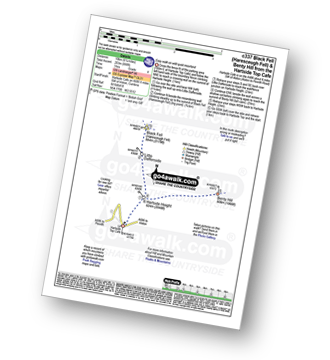
Vital Statistics:
| Length: | 10.25 miles (16.5 km) |
| Ascent: | 2,002ft (610m) |
| Time: | 5.75hrs |
| Grade: | |
Route Summary:
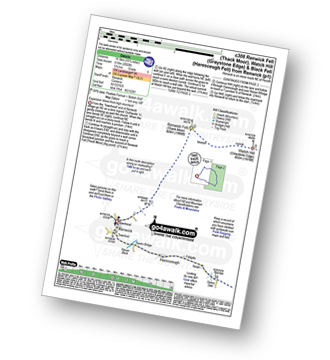
Renwick - Townend - Renwick Fell (Thack Moor) - Watch Hill (Graystone Edge) - Black Fell (Haresceugh Fell) - Little Daffenside - Hartside Height - Hartside Top Cafe (A686) - Ricker Gill - Seavy Sike - Haresceugh - Raven Bridge - Townfoot - Renwick
Not familiar with the area around CA10?
See these 30 nearest walks to UK Postcode CA10 on a google map


