UK Postcode BD24 - The 30 nearest easy-to-follow, circular walk route maps to you
The thirty nearest easy-to-follow, circular walk route maps to you in UK Postcode BD24 in Walk Grade Order
The UK cities, towns and villages in North Yorkshire, England that have BD24 in their UK Postcode include:
• Cleatop • Giggleswick • Helwith Bridge • High Birkwith • Horton in Ribblesdale • Langcliffe • New Houses • Rathmell • Selside • Settle • Stackhouse • Stainforth • Studfold • Wham •
Not familiar with the area around BD24?
See these 30 nearest walks to UK Postcode BD24 on a google map
  |
Vital Statistics:
| Length: | 4.5 miles (7 km) |
| Ascent: | 977ft (298m) |
| Time: | 2.75hrs |
| Grade: |  |
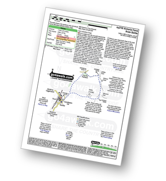
Route Summary:
Settle - Constitution Hill - Attermire - Attermire Scar - Warrendale Knotts - Victoria Cave - Clay Pits Plantation - Blua Crags - Settle
 |
Vital Statistics:
| Length: | 8.25 miles (13 km) |
| Ascent: | 1,279ft (390m) |
| Time: | 4.25hrs |
| Grade: |  |

Route Summary:
Settle - Constitution Hill - Attermire - Attermire Scar - Victoria Cave - Clay Pits Plantation - Upper Winskill - Catrigg Force (waterfall) - Stainforth - Langcliffe - Settle
|
Vital Statistics:
| Length: | 14 miles (22.5 km) |
| Ascent: | 2,562ft (781m) |
| Time: | 7½ hrs |
| Grade: |  |
Route Summary:
Settle - Constitution Hill - Attermire Scar - Victoria Cave - Stickdale Farm - Malham - Malham Cove - Limestone Pavement - Watlowes - Langscar Gate - Outside - Gorbeck - Jubilee Cave - Clay Pits Plantation - Settle
|
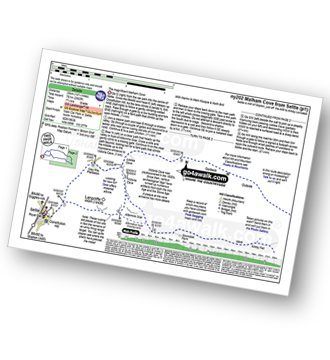
Vital Statistics:
| Length: | 7.5 miles (12 km) |
| Ascent: | 1,296ft (395m) |
| Time: | 4 hrs |
| Grade: | |

Route Summary:
Malham - The Pennine Way - Gordale Beck - New Laithe - Mantley Field Laithe - Janet's Foss - Gordale Bridge - Gordale Scar - New Close - Seaty Hill - Street Gate - Great Close Scar - Great Close Plantation - Malham Tarn - The Pennine Way - Malham Beck - Water Sinks - Comb Hill - Ing Scar Crag - Watlowes - Malham Cove - Malham
|
Vital Statistics:
| Length: | 5 miles (8 km) |
| Ascent: | 804ft (245m) |
| Time: | 2½ hrs |
| Grade: |  |
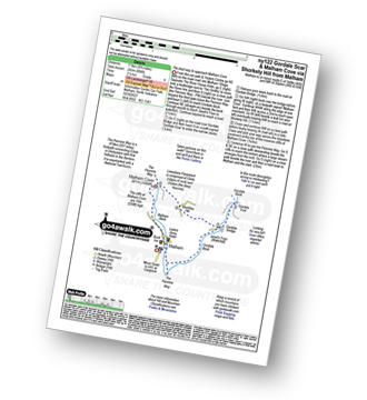
Route Summary:
Malham - The Pennine Way - Gordale Beck - New Laithe - Mantley Field Laithe - Janet's Foss - Gordale Bridge - Gordale Scar - Gordale Bridge - Cawden Flats Barn - Shorkley Hill - Sheriff Hill - Malham Cove - Malham Beck - Malham
|
Vital Statistics:
| Length: | 10 miles (16 km) |
| Ascent: | 1,663ft (506m) |
| Time: | 5 hrs |
| Grade: |  |
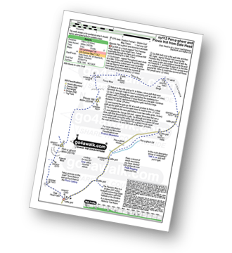
Route Summary:
Dale Head - The Pennine Way - Gavel Rigg - Pen-y-ghent - Plover Hill - Foxup Moor - Foxup Road - Low Bergh - Littondale - Pen-y-ghent Gill - Dale Head
|
Vital Statistics:
| Length: | 11.5 miles (18.5 km) |
| Ascent: | 1,961ft (598m) |
| Time: | 6.25hrs |
| Grade: | |

Route Summary:
Dale Head - The Pennine Way - Fountains Fell - Fountains Fell (South Top) - Fountains Fell Tarn - Darnbrook Fell - Wilson's Pasture - River Skirfare - Nether Hesleden Farm - Pen-y-ghent Gill - Dale Head
|
Vital Statistics:
| Length: | 8.75 miles (14 km) |
| Ascent: | 1,162ft (354m) |
| Time: | 4½ hrs |
| Grade: | |

Route Summary:
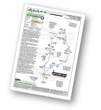
Street Gate - Great Close Plantation - Great Close Scar - Middle House Farm - Low Midge Hills - High Midge Hills - Middle House - Out Pasture - Middle House Hill - Dew Bottoms - Parson's Pulpit - Lee Gate High Mark - Rabbit Rock - Proctor High Mark - Tommy High Pasture - Mastiles Lane - Street Gate
|
Vital Statistics:
| Length: | 6.25 miles (10 km) |
| Ascent: | 902ft (275m) |
| Time: | 3.25hrs |
| Grade: | |
Route Summary:
Street Gate - Great Close Plantation - Great Close Scar - Middle House Farm - Low Midge Hills - High Midge Hills - Middle House - Out Pasture - Middle House Hill - Dew Bottoms - Parson's Pulpit - East Great Close - Gordale Beck - Street Gate
|
Vital Statistics:
| Length: | 7.5 miles (12 km) |
| Ascent: | 909ft (277m) |
| Time: | 3.75hrs |
| Grade: | |
Route Summary:
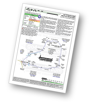
Street Gate - Gordale Beck - East Great Close - Clapham High Mark - Lee Gate High Mark - Rabbit Rock - Proctor High Mark - Tommy High Pasture - Mastiles Lane - Street Gate
|
Vital Statistics:
| Length: | 10.25 miles (16.5 km) |
| Ascent: | 2,136ft (651m) |
| Time: | 6 hrs |
| Grade: | |

Route Summary:
Horton in Ribblesdale - Pen-y-ghent Cafe - Brackenbottom - Gavel Rigg - The Pennine Way - Pen-y-ghent - Hunt Pot - Hull Pot - Whitber Hill - God's Bridge - Brow Gill Beck - Nether Lodge - River Ribble - Lodge Hall (or Ingman Lodge) - Ribblehead - Ribblehead Railway Station - Train Journey - Horton in Ribblesdale Railway Station - Horton in Ribblesdale.
|
Vital Statistics:
| Length: | 10.25 miles (16.5 km) |
| Ascent: | 2,136ft (651m) |
| Time: | 6 hrs |
| Grade: | |
Route Summary:
Horton in Ribblesdale - Pen-y-ghent Cafe - Brackenbottom - Gavel Rigg - The Pennine Way - Pen-y-ghent - Hunt Pot - Hull Pot - Whitber Hill - God's Bridge - Brow Gill Beck - Nether Lodge - River Ribble - Lodge Hall (or Ingman Lodge) - Ribblehead - Ribblehead Railway Station - Train Journey - Horton in Ribblesdale Railway Station - Horton in Ribblesdale.
|
Vital Statistics:
| Length: | 8.75 miles (14 km) |
| Ascent: | 1,827ft (557m) |
| Time: | 5 hrs |
| Grade: | |

Route Summary:
Horton In Ribblesdale - Brackenbottom - Gavel Rigg - The Pennine Way - Pen-y-ghent - Plover Hill - Foxup Moor - Swarth Gill Gate - Black Banks - Turpen - Horton Moor - Hull Pot - The Pennine Way - Horton Scar Lane - Horton In Ribblesdale
|
Vital Statistics:
| Length: | 24 miles (38.5 km) |
| Ascent: | 5,297ft (1,614m) |
| Time: | 14 hrs |
| Grade: |  |

Route Summary:
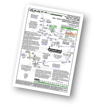
Horton in Ribblesdale - Pen-y-ghent Cafe - Brackenbottom - Gavel Rigg - The Pennine Way - Pen-y-ghent - Hunt Pot - Hull Pot - Whitber Hill - God's Bridge - Brow Gill Beck - Nether Lodge - River Ribble - Lodge Hall (or Ingman Lodge) - Ribblehead - Blea Moor - Whernside - Broadrake Farm - Chapel-le-Dale - Braithwaite Wife Hole - Ingleborough - Pen-y-ghent Cafe - Horton in Ribblesdale.
|
Vital Statistics:
| Length: | 6.25 miles (10 km) |
| Ascent: | 1,640ft (489m) |
| Time: | 4 hrs |
| Grade: | |

Route Summary:
Horton in Ribblesdale - Brackenbottom - Gavel Rigg - The Pennine Way - Pen-y-ghent - Hunt Pot - Hull Pot - Horton in Ribblesdale.
Not familiar with the area around BD24?
See these 30 nearest walks to UK Postcode BD24 on a google map
|
Vital Statistics:
| Length: | 10.5 miles (17 km) |
| Ascent: | 1,566ft (477m) |
| Time: | 5½ hrs |
| Grade: | |
Route Summary:
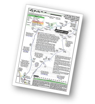
Horton In Ribblesdale - The Pennine Way - Sell Gill Holes - Sell Gill Beck - Red Moss Pot - Birkwith Moor - Birkwith Common - Green Haw Moor - Cosh Knott Well - Cosh Outside (Cosh Knott) - High Green Field Knott (Cosh Knott) - Cosh Beck Head - Lante Shop Caves - Cosh Water Gap - Black Banks - Turpen Horton Moor - Hull Pot Beck - Hull Pot - Hunt Pot - Horton Scar Lane - Horton In Ribblesdale
|
Vital Statistics:
| Length: | 4 miles (6.5 km) |
| Ascent: | 558ft (170m) |
| Time: | 2 hrs |
| Grade: |  |

Route Summary:
Clapham - Limekiln Plantation - Clapdale Farm - Ingleborough Cave - Trow Gill - Long Lane (Track) - Thwaite Scars - Thwaite Lane (Track) - Clapham
|
Vital Statistics:
| Length: | 8.25 miles (13 km) |
| Ascent: | 951ft (290m) |
| Time: | 3.75hrs |
| Grade: | |

Route Summary:
Clapham - Ingleborough Hall - Thwaite Lane - Summit Clump - Robin Proctor's Scar - Norber Brow - Nappa Scars - Crummack Lane - Crummack Farm - Crummack Dale - Begger's Stile - Thieves Moss - Sulber Gate - Long Scar - Long Lane (Track). Thwaite Scars - Clapham
|
Vital Statistics:
| Length: | 8.5 miles (13.5 km) |
| Ascent: | 2,178ft (664m) |
| Time: | 5 hrs |
| Grade: | |

Route Summary:
Clapham - Limekiln Plantation - Clapdale Farm - Ingleborough Cave - Trow Gill - Hernal Moss - Gaping Gill - Seat Haw - Little Ingleborough - Ingleborough - Little Ingleborough - Newby Moss - Cote Haw - Newby Cote - Clapham
|
Vital Statistics:
| Length: | 10.5 miles (16.5 km) |
| Ascent: | 1,697ft (499m) |
| Time: | 5½ hrs |
| Grade: | |
Route Summary:
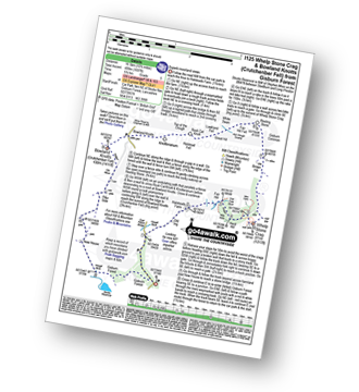
Gisburn Forest - Halsteads Farm - Fair Hill - Herd Hill - Whelp Stone Crag - Brown Hill - Gisburn Common - Resting Stone - Ash Clough Swamp - Lawkland Fell - Rock Cat Knoll - Halstead Fell - Knotteranum - Crutchenber Fell (Bowland Knotts) - Pike Side - New House - Hasgill Beck - Stocks Reservoir - Gisburn Forest
|
Vital Statistics:
| Length: | 7 miles (11 km) |
| Ascent: | 1,224ft (373m) |
| Time: | 3.75hrs |
| Grade: | |
Route Summary:
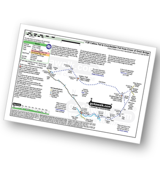
Cross of Greet Bridge - The River Hodder - Cross of Greet - Great Harlow - Raven's Castle - Crowd Stones - Catlow Fell (Ravens Castle) - Hailshowers Fell - Cold Stone - Copy Nook - Knottend Well - Crutchenber Fell (Bowland Knotts) - Pike Side - Catlow Farm - Kearsdon Holes - The River Hodder - Cross of Greet Bridge
|
Vital Statistics:
| Length: | 5.75 miles (9 km) |
| Ascent: | 1,113ft (339m) |
| Time: | 3.25hrs |
| Grade: | |

Route Summary:
Cross of Greet Bridge - Near Crosty Clough - Shooters' Huts - Far Costy Clough - White Hill (Forest of Bowland) - Botton Head Hill - Whitray Fell - Cross of Greet - Cross of Greet Bridge
|
Vital Statistics:
| Length: | 8.75 miles (14 km) |
| Ascent: | 1,615ft (492m) |
| Time: | 5 hrs |
| Grade: | |
Route Summary:
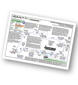
Cross of Greet Bridge - Near Crosty Clough - Shooters' Huts - Far Costy Clough - White Hill (Forest of Bowland) - Botton Head Hill - Whitray Fell - Cross of Greet - Great Harlow - Raven's Castle - Crowd Stones - Catlow Fell (Ravens Castle) - Hailshowers Fell - Cold Stone - Copy Nook - Knottend Well - Crutchenber Fell (Bowland Knotts) - Pike Side - Catlow Farm - Kearsdon Holes - The River Hodder - Cross of Greet Bridge
|
Vital Statistics:
| Length: | 9 miles (14.5 km) |
| Ascent: | 1,132ft (345m) |
| Time: | 4½ hrs |
| Grade: | |
Route Summary:
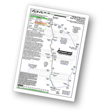
The Great Stone of Forstone - Moor Cock Farm - Tatham Fells - Bank End Gate - Lyth Fell - Starkers Moor - Whitray Fell - Cross of Greet - Great Harlow - Raven's Castle - Crowd Stones - Thistley Hill - Thistle Hill - Tanstree Cragg - Burn Moor Fell - Hart Pot Gill - Stony Bank - Red Mire Queen of The Fairies Chair - Loftshaw Moss - The Great Stone of Forstone
|
Vital Statistics:
| Length: | 9.5 miles (15 km) |
| Ascent: | 2,362ft (720m) |
| Time: | 5.75hrs |
| Grade: | |

Route Summary:
Ingleton - Ingleton Tourist Information Centre - Fell Lane - Crina Bottom Farm - Quaking Pot - Ingleborough - Humphrey Bottom - Ingleborough Nature Reserve - Raven Scar - High Howeth - Harry Hallam's Moss - White Scars - Ingleton
|
Vital Statistics:
| Length: | 5 miles (8 km) |
| Ascent: | 961ft (293m) |
| Time: | 3 hrs |
| Grade: | |

Route Summary:
Ingleton - Thornton Hall Farm - Kingsdale - River Dow - The Ingleton Waterfalls Trail Beezley Falls - Rival Falls - Snow Falls - Ingleton
|
Vital Statistics:
| Length: | 9.5 miles (15 km) |
| Ascent: | 2,250ft (686m) |
| Time: | 5½ hrs |
| Grade: | |
Route Summary:
Ingleton - Ingleton Information Centre - Richmond House - Fell Lane - Crina Bottom Farm - Quaking Pot - Ingleborough - Little Ingleborough - Newby Moss - Newby Cote - Bleak Bank - Duck Dub - Holly Platt - Slatenber - Jenkin Bridge - Ingleton
|
Vital Statistics:
| Length: | 8 miles (12.5 km) |
| Ascent: | 1,280ft (390m) |
| Time: | 4.25hrs |
| Grade: | |
Route Summary:
Slaidburn - King Syke - Broadhead Farm - Easington Brook - Skelshaw Brook - Skelshaw Farm - Fell Side Farm - Harrop Fell - Easington Fell - Old Ned - Old Ned's Wife - Sadler Hill - Smelfthwaite Farm - Meanley Farm - Fowler's Laithe - Newton - River Hodder - Dunnow Hall - Dunnow Lodge - Slaidburn
|
Vital Statistics:
| Length: | 10 miles (16 km) |
| Ascent: | 2,244ft (684m) |
| Time: | 5.75hrs |
| Grade: | |

Route Summary:
Ingleton - Fell Lane - Crina Bottom Farm - Quaking Pot - Ingleborough - Humphrey Bottom - Ingleborough Nature Reserve - Braithwaite Wife Hole - Souther Scales Farm - Chapel-le-Dale - Twistleton Scars - Oddies Lane - The Ingleton Waterfalls Trail - Beezley Falls - Snow Falls - Ingleton
|
Vital Statistics:
| Length: | 16.5 miles (26 km) |
| Ascent: | 2,447ft (746m) |
| Time: | 8½ hrs |
| Grade: | |

Route Summary:
Ingleton - Thornton Hall Farm - Tow Scar - Gragareth - Green Hill (Gragareth) - Lancashire County Stone - High Pike - Kingsdale Beck - Braida Garth Farm - Twistleton Hall Farm - The Ingleton Waterfalls Trail - Beezley Falls - River Doe - Snow Falls - Ingleton
Not familiar with the area around BD24?
See these 30 nearest walks to UK Postcode BD24 on a google map


