Four easy to follow pub walks from The Jervis Arms, Onecote, The Peak District, Staffordshire, England
To reach The Jervis Arms, Onecote, in-car SatNav users should select the Latitude/Longitude (Lat Lon) screen and enter:
Lat = N53.09400 and Lon = W 1.9266
Not familiar with this pub?
Four easy to follow pub walks from The Jervis Arms, Onecote, The Peak District, Staffordshire, England
Scroll down the list of walks below & click on each walk title (in blue) to locate it on the map above.
   |
Vital Statistics:
| Length: | 7.75 miles (12.5 km) |
| Ascent: | 1,139ft (347m) |
| Time: | 4 hrs |
| Grade: |  |
Route Summary:
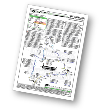
Onecote - Hamps Way - Onecote Grange - The River Hamps - Mixon Mines - Black Brook Farm - Breech Farm - Under The Hill Farm - Upper Elkstone - Ryecroft Farm - Hole Farm - Hill Farm - Butterton - The Twist - Grindon Moor (Grindon Moor) - Home Farm - Onecote
|
Vital Statistics:
| Length: | 11.5 miles (18 km) |
| Ascent: | 1,267ft (386m) |
| Time: | 5½ hrs |
| Grade: | |

Route Summary:
Waterhouses - Waterfall Cross - Martins Low - River Hamps - Ford - Onecote - Grindonmoor Gate - Grindon Moor (Grindon Moor) - Grindon - Lee House - The Manifold Way - Waterhouses
|
Vital Statistics:
| Length: | 9.5 miles (15 km) |
| Ascent: | 1,641ft (500m) |
| Time: | 5 hrs |
| Grade: | |

Route Summary:
Butterton - Hoo Brook - The Twist - Grindon Moor - Onecote - Waterhouse - Old Mixon Hey Farm - Manor Farm - Hill House - Under The Hill Farm - Upper Elkstone - Ryecroft Farm - Hole Farm - Hill Farm - Butterton
|
Vital Statistics:
| Length: | 9.5 miles (15 km) |
| Ascent: | 1,483ft (452m) |
| Time: | 5 hrs |
| Grade: |  |

Route Summary:
Warslow - Villa Farm - Clayton House - Wallacre - Hoo Brook - Butterton - The Twist - Grindon Moor (Grindon Moor) - Onecote - Butterton Moor End Farm - Butterton Moor - Golden Hill - Black Brook Farm - Breech Farm - Underhill Farm - Upper Elkstone - Moorside - Cowhay Head - Warslow


