
![]()
Hard Knott
549m (1802ft)
The Southern Fells, The Lake District, Cumbria, England
Not familiar with this top?
You can walk/hike to the top of Hard Knott by using either of these 2 easy‑to‑follow route maps:
Walk c280 Hard Knott from Jubilee Bridge, Eskdale
Rough fell walking on faint paths
   |
|---|
Vital Statistics:
| Length: | 6.25ml (10km) |
|---|---|
| Ascent: | 1,756ft (535m) |
| Time: | 4 hrs |
| Grade: |  (Moderate) (Moderate) |
Route Summary:
Eskdale - Jubilee Bridge - Hardknott Pass - Hardknott Castle. (Roman Fort) - Hardknott Pass - Hard Knott - Yew Bank - Lingcove Beck - Lingcove Bridge - Great Moss - River Esk - Jubilee Bridge - Eskdale
Walk c402 Harter Fell and Hard Knott from The Woolpack Inn, Eskdale
Some of the quieter fells
|
|---|
Vital Statistics:
| Length: | 12.25ml (19.5km) |
|---|---|
| Ascent: | 3,568ft (1,087m) |
| Time: | 8 hrs |
| Grade: |  (Hard) (Hard) |

Route Summary:
Eskdale - The Woolpack Inn - Doctor Bridge - Low Birker - Birker Force - Low Birker Tarn - Green Crag (Ulpha Fell) - Crook Crag - Harter Fell (Eskdale) - Dunnerdale Forest - Hardknott Pass - Hardknott Gill - Hard Knott - Yew Bank - Lingcove Beck - Lingcove Bridge - Great Moss - Brotherilkeld - Taw House Farm - Wha House Farm - The River Esk - The Woolpack Inn - Eskdale
See Hard Knott and the surrounding tops on our free-to-access 'Google Style' Peak Bagging Maps:
The Southern Fells of The Lake District National Park
Less data - quicker to download
The Whole of The Lake District National Park
More data - might take a little longer to download
See Hard Knott and the surrounding tops on our unique, downloadable, PDF Peak Bagging Maps:

NB: Whether you print off a copy or download it to your phone, these PDF Peak Baggers' Maps might prove incredibly useful when your are up there on the tops and you cannot get a phone signal.
*This version is marked with the walk routes you need to follow to Walk all 214 Wainwrights in just 59 walks.
You can find Hard Knott & all the walks that climb it on these unique free-to-access Interactive Walk Planning Maps:
1:25,000 scale OS Explorer Map (orange/yellow covers):
1:50,000 scale OS Landranger Maps (pink/magenta covers):
 Fellow go4awalkers who have already walked, climbed, scaled, summited, hiked & bagged Hard Knott
Tim Winn walked up Hard Knott on May 17th, 2025 [from/via/route] Hard Knott Pass [with] Jane [weather] Dry. Sunny.
James Hughes climbed it on April 29th, 2025 [from/via/route] c402 Harter Fell & Hard Knott from Eskdale [weather] Glorious sunny day. Warm & clear. - Up to Green Crag from Woolpack Inn. Issue locating path initially as permissive path at Low Birker overshoots it. Boggy between Green Crag & Harter Fell. Awesome views at top. Relatively easy ascent to Hard Knott. Long descent back to WoolpackInn alongside beautiful Lingcove Beck.
Caroline Winter bagged it on October 11th, 2024 [from/via/route] Hardknott pass by cairn, raven crag edge, Border End, Hardknott fell [with] Solo [weather] Predicted good views, sun & cloud, but drizzle & cloud descending over Scafell. - Reasonable views over Scafell ranges. At the grassy knoll below Border End could view the needle. Decided to go up to Border End cairn & could see great aerial views of the Roman ruins
Richard Fulcher hiked Hard Knott on June 22nd, 2024 [from/via/route] Drove around the back of the Lakes to Eskdale & parked near Hardknott Castle. After having a look at the Roman remains we walked up a path that joined with the road near the top of Hardknott pass. From there we turned left & followed a stony & later boggy path up to Hard Knott. Returned by the same route. [with] Jen [weather] Sunny with some cloud, no rain but blustery on the tops. - Fantastic view towards Scafell & Scafell Pike.
Christine Shepherd summited on August 19th, 2009 [from/via/route] Walked from the bottom of Hard Knott Pass Climbed again on 20.11.2021. Walked from Jubilee Bridge for my third ascent on 10.5.24.in glorious weather. Had the best views I have ever had from the summit. [with] On my own [weather] Wet & warm
To add (or remove) your name and experiences on this page - Log On and edit your Personal Mountain Bagging Record
. . . [see more walk reports]
More Photographs & Pictures of views from, on, or of, Hard Knott

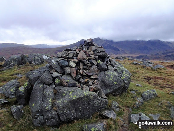
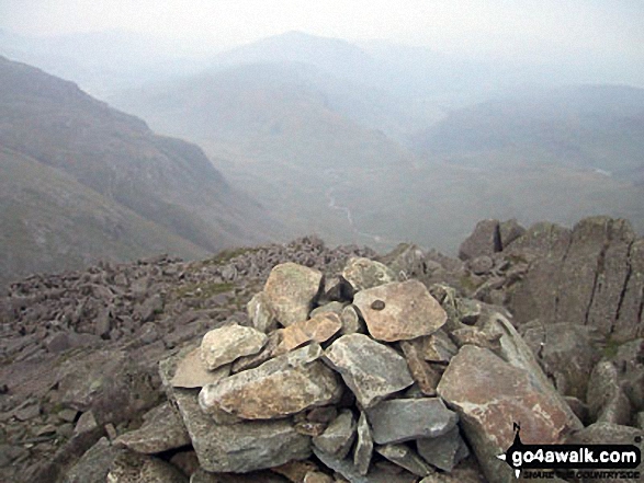
Hard Knott summit cairn - with Esk Pike, Bow Fell (Bowfell) and Crinkle Crags gracing the skyline
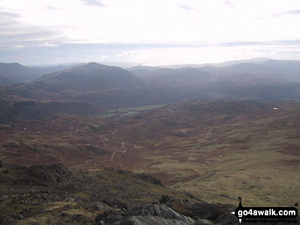
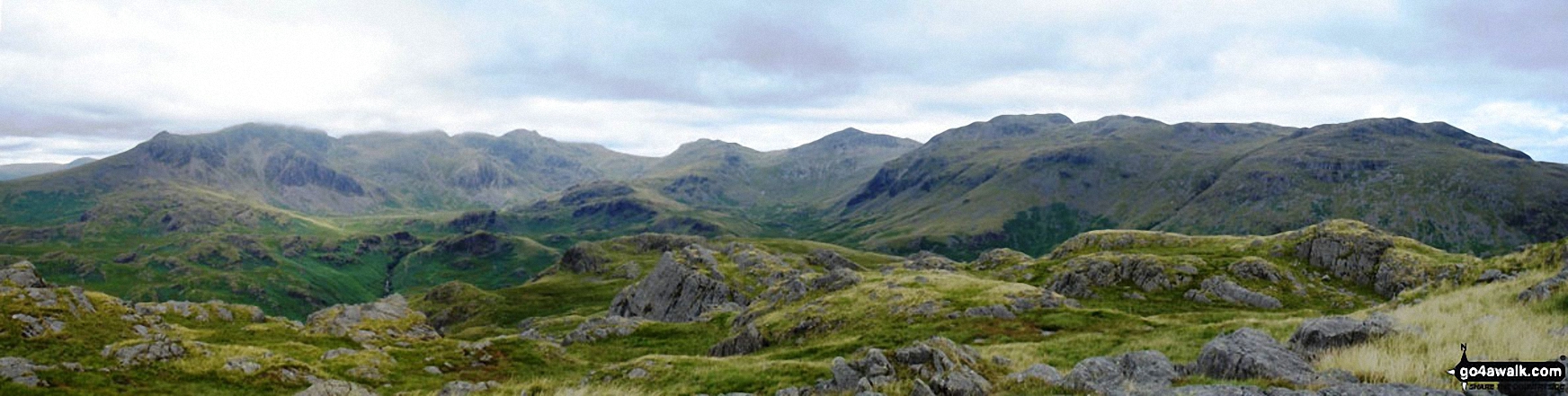
*Northernly Panorama from the summit of Hard Knott featuring Sca Fell, Scafell Pike, Esk Pike, Bow Fell (Bowfell), Gunson Knott, Crinkle Crags (Long Top) and Crinkle Crags (South Top)
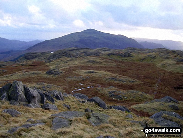


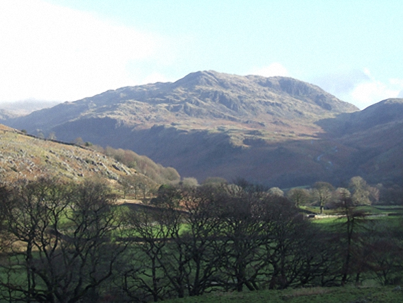
Looking south west towards Hard Knott, Harter Fell (Eskdale), Lingcove Bridge and Eskdale from the summit of Bow Fell (Bowfell)

Harter Fell (Eskdale) (back), Hard Knott and The Lingcove Valley from Bow Fell (Bowfell) summit cairn
. . . see all 14 walk photographs & pictures of views from, on, or of, Hard Knott
Send us your photographs and pictures on, of, or from Hard Knott
If you would like to add your walk photographs and pictures to this page, please send them as email attachments (configured for any computer) along with your name to:
and we shall do our best to publish them.
(Guide Resolution = 300dpi. At least = 660pixels (wide) x 440 pixels (high).)

You can also submit photos via our Facebook Page.
NB. Please indicate where each photo was taken and whether you wish us to credit your photos with a Username or your First Name/Last Name.


