
![]()
Pen y Fan (Dinas Head)
142m (466ft)
West Wales, The Pembrokeshire Coast, Pembrokeshire, Wales
The summit of Pen y Fan (Dinas Head) is marked by an Ordnance Survey Trig Point.

Not familiar with this top?
You can walk/hike to the top of Pen y Fan (Dinas Head) by using either of these 2 easy‑to‑follow route maps:
Walk pe121 Pen y Fan (Dinas Head) from Cwm-yr-Eglwys
Lovely coastal walk
   |
|---|
Vital Statistics:
| Length: | 3mls (5km) |
|---|---|
| Ascent: | 735ft (224m) |
| Time: | 2 hrs |
| Grade: |  (Easy) (Easy) |
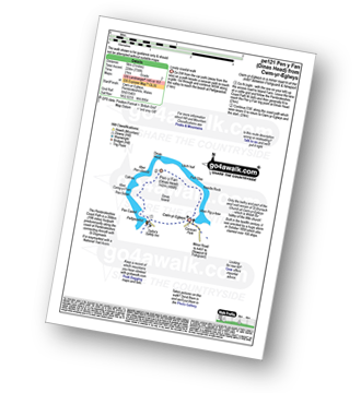
Route Summary:
Cwm-yr-Eglwys - The Pembrokeshire Coast Path - Aber Pig-y-baw - Needle Rock - Llech Isaf - Pen y Fan (Dinas Head) - Aber Pen-clawdd - Cafnau - Aber Careg-y-Fran - Pen Sidan - Pen Castell - Pwllgwaelod - Cwm-yr-Eglwys
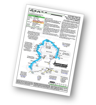
Walk pe110 Aber Bach and Pen y Fan (Dinas Head) from Cwm-yr-Eglwys
Superb Coastal Walk
|
|---|
Vital Statistics:
| Length: | 5.75mls (9km) |
|---|---|
| Ascent: | 1,397ft (426m) |
| Time: | 3½ hrs |
| Grade: |  (Moderate) (Moderate) |
Route Summary:
Cwm-yr-Eglwys - The Pembrokeshire Coast Path - Bryn-henllan - Dinas Cross - Aber Bach - Pwllgwaelod - Pen Castell - Pen Sidan - Aber Careg-y-Fran - Cafnau - Aber Pen-clawdd - Pen y Fan (Dinas Head) - Llech Isaf - Pell Glas - Needle Rock - Aber Pig-y-baw - Cwm-yr-Eglwys
A go4awalk.com downloadable Peak Bagging Map in PDF format featuring Pen y Fan (Dinas Head) should be available soon.
You can find Pen y Fan (Dinas Head) & all the walks that climb it on these unique free-to-access Interactive Walk Planning Maps:
1:25,000 scale OS Explorer Map (orange/yellow covers):
1:50,000 scale OS Landranger Maps (pink/magenta covers):
 Fellow go4awalkers who have already walked, climbed, scaled, summited, hiked & bagged Pen y Fan (Dinas Head)
To add (or remove) your name and experiences on this page - Log On and edit your Personal Mountain Bagging Record
Send us your photographs and pictures on, of, or from Pen y Fan (Dinas Head)
If you would like to add your walk photographs and pictures to this page, please send them as email attachments (configured for any computer) along with your name to:
and we shall do our best to publish them.
(Guide Resolution = 300dpi. At least = 660pixels (wide) x 440 pixels (high).)

You can also submit photos via our Facebook Page.
NB. Please indicate where each photo was taken and whether you wish us to credit your photos with a Username or your First Name/Last Name.


