
![]()
Tinside Rigg
624m (2048ft)
The North Pennines, Cumbria, England
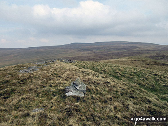
The summit of Tinside Rigg is marked by a rocky outcrop..
Tinside Rigg is inside the Warcop Army Training Area. For safety reasons, public access is restricted to public rights of way during non-firing days only. Access is only permitted during the Christmas period and approximately 12 other weekends per year, which are publicly notified 12 months in advance. Information about these weekends can be obtained by calling 0800 783 5181 or visiting Warcop MoD Firing Range Access Dates. The website is best for long-range planning, while the phone number gives more up-to-date information for the next couple of weeks or so.
Tinside Rigg was promoted to 'Nuttall' status in November, 2016
Not familiar with this top?
You can walk/hike to the top of Tinside Rigg by using this easy‑to‑follow route map:
Walk c496 Tinside Rigg and Long Fell from Hilton
Two difficult to reach 'Nuttalls'
   |
|---|
Vital Statistics:
| Length: | 7mls (11km) |
|---|---|
| Ascent: | 1,381ft (421m) |
| Time: | 4 hrs |
| Grade: |  (Moderate) (Moderate) |
Route Summary:
Hilton Town Head - Hilton Beck - Warcop Training Area - Swindale Brow - Swindale Beck - Swindale Edge - Marn Gill - Christy Bank - Siss Gill - Tinside Rigg - Long Fell - Howgill Fold - Cringle Beck - Lycum Sike - East Moor - Hilton Sike - Hilton Town Head
See Tinside Rigg and the surrounding tops on our free-to-access 'Google Style' Peak Bagging Map:
The North Pennines
Less data - quicker to download
See Tinside Rigg and the surrounding tops on our unique, downloadable, PDF Peak Bagging Map:

NB: Whether you print off a copy or download it to your phone, this PDF Peak Baggers' Map might prove incredibly useful when your are up there on the tops and you cannot get a phone signal.
You can find Tinside Rigg & all the walks that climb it on these unique free-to-access Interactive Walk Planning Maps:
1:25,000 scale OS Explorer Map (orange/yellow covers):
1:50,000 scale OS Landranger Map (pink/magenta covers):
 Fellow go4awalkers who have already walked, climbed, scaled, summited, hiked & bagged Tinside Rigg
Kevin Foster walked up Tinside Rigg on August 26th, 2018 [from/via/route] Hilton. [with] By myself. [weather] Rain followed by rain then more rain. - This walk is in the Warcop training area (WTA) & so the number of access days are strictly limited. The approach from Hilton up the Scordale valley & then along Swindale edge was delightful & route finding almost to the top of Tinside Rigg itself was made easy by the guide posts dotted along the route. The small cairn marking the summit of Tinside Rigg at spot height 624m wasn't in doubt. The top of the next nuttall Long Fell could have been one of two but I settled for the spot height at 622m marked by an artillery shell which must have been placed there surely? The toughest part of the walk was the descent then pathless climb to the summit of Roman Fell across rough grass, heather & bog. The summit being marked by an ancient cairn & wind shelter that's not on the maps.
Christine Shepherd climbed it on April 30th, 2017 [from/via/route] Walked from Hilton along Swindale Edge & Christy Bank then over Tinside Rigg, Long Fell & Roman Fell. [with] On my own [weather] Dry & pleasant. A bit breezy but the wind wasn't cold so it was fine. - The walk up Swindale Edge is great, clear makers all the way. Make sure you check the access days for this fell as it is on Warcop MOD land.
To add (or remove) your name and experiences on this page - Log On and edit your Personal Mountain Bagging Record
More Photographs & Pictures of views from, on, or of, Tinside Rigg
Send us your photographs and pictures on, of, or from Tinside Rigg
If you would like to add your walk photographs and pictures to this page, please send them as email attachments (configured for any computer) along with your name to:
and we shall do our best to publish them.
(Guide Resolution = 300dpi. At least = 660pixels (wide) x 440 pixels (high).)

You can also submit photos via our Facebook Page.
NB. Please indicate where each photo was taken and whether you wish us to credit your photos with a Username or your First Name/Last Name.


