The Mountains, Peaks, Tops and Hills in The Glyders (or Glyderau) area of Snowdonia, Conwy and Gwynedd with all the tops you have already bagged in first & then the ones you are yet to climb second.
The Glyders (or Glyderau) area of Snowdonia National Park, Conwy and Gwynedd is enclosed by:
- Bethesda to the North
- The A5 via Nant Ffrancon, Llyn Ogwen & Nant y Benglog to the North East
- Capel Curig to the East
- The A4086 via The Pass of Llanberis & Dyffryn Mymbyr to the South
- The edge of the Snowdonia National Park to the West
If you include just the Mountains (Hewitts) and the Nuttalls there are 12 tops to climb, bag & conquer and the highest point is Glyder Fawr at 999m (3,279ft).
To see these Mountains, Peaks, Tops and Hills displayed in different ways - see the options in the left-hand column and towards the bottom of this page.
![]() Your Personal Bagging Record for The Glyders (or Glyderau) area of Snowdonia
Your Personal Bagging Record for The Glyders (or Glyderau) area of Snowdonia
LOG ON and RELOAD this page to show which Mountains, Peaks, Tops and Hills you have already climbed, bagged & conquered [. . . more details]
Scroll down this list of mountains, peaks, tops & hills below and tap/click on each name (in blue) to locate it on the map above.
See this list in: Alphabetical Order‡ | Height Order
To reverse the order select the link again.
Mountain, Peak, Top or Hill already bagged:
Bagged
Top yet to be climbed, bagged & conquered:
Bagged

![]()
1. Carnedd y Filiast (Glyderau)
822m (2698ft)
Mountain (Hewitt) and Nuttall
See more details, photos, trip reports and easy-to-follow walks up Carnedd y Filiast (Glyderau)

![]()
2. Carnedd y Filiast (Glyderau) (North Top)
721m (2366ft)
Nuttall
![]()
3. Castell y Gwynt (Glyder Fach)
972m (3190ft)
Nuttall
See more details, photos, trip reports and easy-to-follow walks up Castell y Gwynt (Glyder Fach)
![]()
4. Elidir Fawr
924m (3033ft)
Mountain (Hewitt) and Nuttall
See more details, photos, trip reports and easy-to-follow walks up Elidir Fawr
![]()
5. Foel-goch
831m (2727ft)
Mountain (Hewitt) and Nuttall
See more details, photos, trip reports and easy-to-follow walks up Foel-goch
![]()
6. Gallt yr Ogof
763m (2504ft)
Mountain (Hewitt) and Nuttall
See more details, photos, trip reports and easy-to-follow walks up Gallt yr Ogof
![]()
7. Glyder Fach
990m (3249ft)
Mountain (Hewitt) and Nuttall
See more details, photos, trip reports and easy-to-follow walks up Glyder Fach
![]()
8. Glyder Fawr
999m (3279ft)
Mountain (Hewitt) and Nuttall
See more details, photos, trip reports and easy-to-follow walks up Glyder Fawr
![]()
9. Mynydd Perfedd
812m (2665ft)
Nuttall
See more details, photos, trip reports and easy-to-follow walks up Mynydd Perfedd
![]()
10. Tryfan
915m (3003ft)
Mountain (Hewitt) and Nuttall
See more details, photos, trip reports and easy-to-follow walks up Tryfan
![]()
11. Y Foel Goch
805m (2642ft)
Mountain (Hewitt) and Nuttall
See more details, photos, trip reports and easy-to-follow walks up Y Foel Goch
![]()
12. Y Garn (Glyderau)
947m (3108ft)
Mountain (Hewitt) and Nuttall
See more details, photos, trip reports and easy-to-follow walks up Y Garn (Glyderau)
![]() Your Personal Bagging Record for The Glyders (or Glyderau) area of Snowdonia
Your Personal Bagging Record for The Glyders (or Glyderau) area of Snowdonia
LOG ON and RELOAD this page to show which Mountains, Peaks, Tops and Hills you have already climbed, bagged & conquered [. . . more details]
View these 12 Mountains, Peaks, Tops and Hills:
- On a Downloadable PDF you can Print or Save to your Phone#
- On an Interactive Google Map with a list of tops below it.
(makes it easier to locate a particular top) - On a Detailed List in:
Alphabetical Order | Height Order - On one page with 'yet-to-be-bagged' listed 1st
& then 'already-bagged' tops listed 2nd in:
Alphabetical Order | Height Order - On one page with 'already-bagged' tops listed 1st
& then 'yet-to-be-bagged' tops listed 2nd in:
Alphabetical Order | Height Order
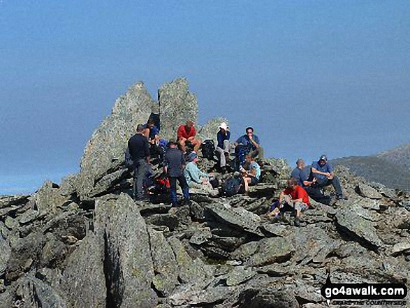 The summit of Glyder Fawr in The Glyders (or Glyderau) area of Snowdonia
Photo: Geoff Smithson
# Whether you print a copy or download it to your phone, this Peak Baggers' Map will prove incredibly useful if you want to know what's what when you are up in the mountains and cannot get a phone signal.
Is there a Mountain, Peak, Top or Hill missing from the above google map or list?