The Mountains, Peaks, Tops and Hills in The North Western Fells area of The Lake District, Cumbria with all the tops you have already bagged in first & then the ones you are yet to climb second.
The North Western Fells area of The Lake District National Park, Cumbria is enclosed by:
- Basenthwaite to the North East
- Keswick, Derwent Water and Borrowdale to the East
- Seatoller and Honister Pass to the South
- Buttermere, Crummock Water & Lorton Vale to the South West
- Cockermouth and the boundary of the Lake District National Park to the West and North West
If you count only the Wainwrights there are 29 tops to climb, bag & conquer and the highest point is Grasmoor at 851m (2,794ft).
To see these Mountains, Peaks, Tops and Hills displayed in different ways - see the options in the left-hand column and towards the bottom of this page.
![]() Your Personal Bagging Record for The North Western Fells area of The Lake District
Your Personal Bagging Record for The North Western Fells area of The Lake District
LOG ON and RELOAD this page to show which Mountains, Peaks, Tops and Hills you have already climbed, bagged & conquered [. . . more details]
Scroll down this list of mountains, peaks, tops & hills below and tap/click on each name (in blue) to locate it on the map above.
See this list in: Alphabetical Order | Height Order‡
To reverse the order select the link again.
Mountain, Peak, Top or Hill already bagged:
Bagged
Top yet to be climbed, bagged & conquered:
Bagged

![]()
1. Castle Crag
290m (952ft)
Wainwright
See more details, photos, trip reports and easy-to-follow walks up Castle Crag
![]()
2. Rannerdale Knotts
355m (1165ft)
Wainwright
See more details, photos, trip reports and easy-to-follow walks up Rannerdale Knotts
![]()
3. Sale Fell
359m (1178ft)
Wainwright
See more details, photos, trip reports and easy-to-follow walks up Sale Fell
![]()
4. Ling Fell (Wythop)
373m (1224ft)
Wainwright
See more details, photos, trip reports and easy-to-follow walks up Ling Fell (Wythop)
![]()
5. Cat Bells (Catbells)
451m (1480ft)
Wainwright
See more details, photos, trip reports and easy-to-follow walks up Cat Bells (Catbells)
![]()
6. Graystones
452m (1483ft)
Wainwright
See more details, photos, trip reports and easy-to-follow walks up Graystones
![]()
7. Barrow (Newlands)
455m (1493ft)
Wainwright
See more details, photos, trip reports and easy-to-follow walks up Barrow (Newlands)
![]()
8. Barf
468m (1536ft)
Wainwright
See more details, photos, trip reports and easy-to-follow walks up Barf
![]()
9. Broom Fell
511m (1677ft)
Wainwright
See more details, photos, trip reports and easy-to-follow walks up Broom Fell
![]()
10. Whinlatter (Brown How)
517m (1697ft)
Wainwright
See more details, photos, trip reports and easy-to-follow walks up Whinlatter (Brown How)
![]()
11. Lord's Seat (Whinlatter)
552m (1812ft)
Wainwright
See more details, photos, trip reports and easy-to-follow walks up Lord's Seat (Whinlatter)
![]()
12. Knott Rigg
556m (1825ft)
Wainwright
See more details, photos, trip reports and easy-to-follow walks up Knott Rigg
![]()
13. Outerside
568m (1864ft)
Wainwright
See more details, photos, trip reports and easy-to-follow walks up Outerside
![]()
14. Maiden Moor
575m (1887ft)
Wainwright
See more details, photos, trip reports and easy-to-follow walks up Maiden Moor
![]()
15. Ard Crags
581m (1906ft)
Wainwright
See more details, photos, trip reports and easy-to-follow walks up Ard Crags
![]()
16. Causey Pike
637m (2091ft)
Wainwright
See more details, photos, trip reports and easy-to-follow walks up Causey Pike
![]()
17. High Spy
653m (2143ft)
Wainwright
See more details, photos, trip reports and easy-to-follow walks up High Spy
![]()
18. Whiteless Pike
660m (2166ft)
Wainwright
See more details, photos, trip reports and easy-to-follow walks up Whiteless Pike
![]()
19. Scar Crags
672m (2205ft)
Wainwright
See more details, photos, trip reports and easy-to-follow walks up Scar Crags
![]()
20. Whiteside (Crummock)
719m (2360ft)
Wainwright
See more details, photos, trip reports and easy-to-follow walks up Whiteside (Crummock)
![]()
21. Hindscarth
727m (2386ft)
Wainwright
See more details, photos, trip reports and easy-to-follow walks up Hindscarth
![]()
22. Robinson
737m (2419ft)
Wainwright
See more details, photos, trip reports and easy-to-follow walks up Robinson
![]()
23. Dale Head (Newlands)
753m (2471ft)
Wainwright
See more details, photos, trip reports and easy-to-follow walks up Dale Head (Newlands)
![]()
24. Hopegill Head
770m (2525ft)
Wainwright
See more details, photos, trip reports and easy-to-follow walks up Hopegill Head
![]()
25. Sail (Derwent Fells)
773m (2536ft)
Wainwright
See more details, photos, trip reports and easy-to-follow walks up Sail (Derwent Fells)
![]()
26. Wandope
773m (2539ft)
Wainwright
See more details, photos, trip reports and easy-to-follow walks up Wandope
![]()
27. Grisedale Pike
791m (2596ft)
Wainwright
See more details, photos, trip reports and easy-to-follow walks up Grisedale Pike
![]()
28. Crag Hill (Eel Crag)
839m (2753ft)
Wainwright
See more details, photos, trip reports and easy-to-follow walks up Crag Hill (Eel Crag)
![]()
29. Grasmoor
851m (2794ft)
Wainwright
See more details, photos, trip reports and easy-to-follow walks up Grasmoor
![]() Your Personal Bagging Record for The North Western Fells area of The Lake District
Your Personal Bagging Record for The North Western Fells area of The Lake District
LOG ON and RELOAD this page to show which Mountains, Peaks, Tops and Hills you have already climbed, bagged & conquered [. . . more details]
View these 29 Mountains, Peaks, Tops and Hills:
- On a Downloadable PDF you can Print or Save to your Phone#
- On an Interactive Google Map with a list of tops below it.
(makes it easier to locate a particular top) - On a Detailed List in:
Alphabetical Order | Height Order - On one page with 'yet-to-be-bagged' listed 1st
& then 'already-bagged' tops listed 2nd in:
Alphabetical Order | Height Order - On one page with 'already-bagged' tops listed 1st
& then 'yet-to-be-bagged' tops listed 2nd in:
Alphabetical Order | Height Order
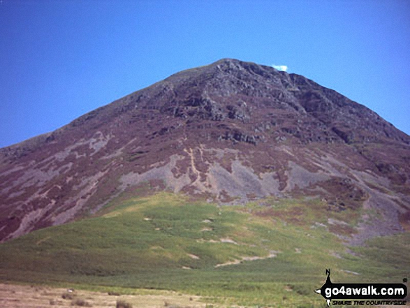 Grasmoor in The North Western Fells area of The Lake District
Photo: William Ringwood
# Whether you print a copy or download it to your phone, this Peak Baggers' Map will prove incredibly useful if you want to know what's what when you are up in the mountains and cannot get a phone signal.
Is there a Mountain, Peak, Top or Hill missing from the above google map or list?