The North West region of England - a fully detailed list of all the Mountains, Peaks, Tops and Hills (Page 9 of 16)
The North West region of England comprises the traditional counties of Cheshire, Cumbria, Greater Manchester, Lancashire and Mersyside and includes The Lake District National Park, The Forest of Bowland, parts of The Yorkshire Dales National Park and parts of the Peak District National Park.
If you include all the Mountains (Hewitts), the Deweys, the Nuttalls, the Marilyns, the Bridgets (Hills) and all the Mountains, Tops, Peaks and Hills with a Trig Point on them there are 464 tops to climb, bag & conquer and the highest point is Scafell Pike at 978m (3,210ft).
To see these Mountains, Peaks, Tops and Hills displayed in different ways - see the options in the left-hand column and towards the bottom of this page.
![]() Your Personal Bagging Record for North West of
Your Personal Bagging Record for North West of
LOG ON and RELOAD this page to show which Mountains, Peaks, Tops and Hills you have already climbed, bagged & conquered [. . . more details]
See this list in: Alphabetical Order‡
| Height Order
To reverse the order select the link again.
Mountain, Peak, Top or Hill:
Bagged

![]()
241. Hobcarton Crag
739m (2,425ft)
Hobcarton Crag is on interactive maps:
Hobcarton Crag is on downloadable PDF you can Print or Save to your Phone: *Version including the walk routes marked on it that you need to follow to Walk all 214 Wainwrights in just 59 walks. |
![]()
242. Hindscarth
727m (2,386ft)
Hindscarth is on interactive maps:
Hindscarth is on downloadable PDF you can Print or Save to your Phone: *Version including the walk routes marked on it that you need to follow to Walk all 214 Wainwrights in just 59 walks. |

![]()
243. Highwatch Currick
639m (2,097ft)
Highwatch Currick is on interactive maps:
|

![]()
244. High Wether Howe
531m (1,743ft)
High Wether Howe is on interactive maps:
A downloadable go4awalk.com PDF Peak Bagging Map featuring High Wether Howe will be available soon. |

![]()
245. High Street
828m (2,717ft)
High Street is on interactive maps:
High Street is on downloadable PDF you can Print or Save to your Phone: *Version including the walk routes marked on it that you need to follow to Walk all 214 Wainwrights in just 59 walks. |

![]()
246. High Stile
807m (2,646ft)
High Stile is on interactive maps:
High Stile is on downloadable PDF you can Print or Save to your Phone: *Version including the walk routes marked on it that you need to follow to Walk all 214 Wainwrights in just 59 walks. |

![]()
247. High Spy (North Top)
634m (2,081ft)
High Spy (North Top) is on interactive maps:
High Spy (North Top) is on downloadable PDF you can Print or Save to your Phone: *Version including the walk routes marked on it that you need to follow to Walk all 214 Wainwrights in just 59 walks. |
![]()
248. High Spy
653m (2,143ft)
High Spy is on interactive maps:
High Spy is on downloadable PDF you can Print or Save to your Phone: *Version including the walk routes marked on it that you need to follow to Walk all 214 Wainwrights in just 59 walks. |
![]()
249. High Snockrigg
526m (1,726ft)
High Snockrigg is on interactive maps:
High Snockrigg is on downloadable PDF you can Print or Save to your Phone: *Version including the walk routes marked on it that you need to follow to Walk all 214 Wainwrights in just 59 walks. |
![]()
250. High Seat (Mallerstang)
709m (2,326ft)
High Seat (Mallerstang) is on interactive maps:
High Seat (Mallerstang) is on downloadable PDF you can Print or Save to your Phone: |

![]()
251. High Seat (Ashness Fell)
608m (1,995ft)
High Seat (Ashness Fell) is on interactive maps:
High Seat (Ashness Fell) is on downloadable PDF you can Print or Save to your Phone: *Version including the walk routes marked on it that you need to follow to Walk all 214 Wainwrights in just 59 walks. |

![]()
252. High Rigg
357m (1,172ft)
High Rigg is on interactive maps:
High Rigg is on downloadable PDF you can Print or Save to your Phone: *Version including the walk routes marked on it that you need to follow to Walk all 214 Wainwrights in just 59 walks. |
![]()
253. High Raise (Mardale)
804m (2,636ft)
High Raise (Mardale) is on interactive maps:
High Raise (Mardale) is on downloadable PDF you can Print or Save to your Phone: *Version including the walk routes marked on it that you need to follow to Walk all 214 Wainwrights in just 59 walks. |
![]()
254. High Raise (Langdale)
762m (2,501ft)
High Raise (Langdale) is on interactive maps:
High Raise (Langdale) is on downloadable PDF you can Print or Save to your Phone: *Version including the walk routes marked on it that you need to follow to Walk all 214 Wainwrights in just 59 walks. |

![]()
255. High Pike (Caldbeck)
658m (2,160ft)
High Pike (Caldbeck) is on interactive maps:
High Pike (Caldbeck) is on downloadable PDF you can Print or Save to your Phone: *Version including the walk routes marked on it that you need to follow to Walk all 214 Wainwrights in just 59 walks. |
![]()
256. High Park
247m (810ft)
High Park is on interactive maps:
|
![]()
257. High House Tarn Top
684m (2,245ft)
High House Tarn Top is on interactive maps:
High House Tarn Top is on downloadable PDF you can Print or Save to your Phone: *Version including the walk routes marked on it that you need to follow to Walk all 214 Wainwrights in just 59 walks. |
![]()
258. High Greygrits (Grey Grit)
522m (1,713ft)
Send it in and we'll publish it here.
High Greygrits (Grey Grit) is on interactive maps:
High Greygrits (Grey Grit) is on downloadable PDF you can Print or Save to your Phone: |
![]()
259. High Dodd (Sleet Fell)
501m (1,644ft)
High Dodd (Sleet Fell) is on interactive maps:
High Dodd (Sleet Fell) is on downloadable PDF you can Print or Save to your Phone: *Version including the walk routes marked on it that you need to follow to Walk all 214 Wainwrights in just 59 walks. |
![]()
260. High Crag (Buttermere)
744m (2,442ft)
High Crag (Buttermere) is on interactive maps:
High Crag (Buttermere) is on downloadable PDF you can Print or Save to your Phone: *Version including the walk routes marked on it that you need to follow to Walk all 214 Wainwrights in just 59 walks. |

![]()
261. High Billinge
178m (584ft)
High Billinge is on interactive maps:
|

![]()
262. Heughscar Hill
375m (1,231ft)
Heughscar Hill is on interactive maps:
A downloadable go4awalk.com PDF Peak Bagging Map featuring Heughscar Hill will be available soon. |
![]()
263. Heron Pike
612m (2,008ft)
Heron Pike is on interactive maps:
Heron Pike is on downloadable PDF you can Print or Save to your Phone: *Version including the walk routes marked on it that you need to follow to Walk all 214 Wainwrights in just 59 walks. |
![]()
264. Hen Comb
509m (1,670ft)
Hen Comb is on interactive maps:
Hen Comb is on downloadable PDF you can Print or Save to your Phone: *Version including the walk routes marked on it that you need to follow to Walk all 214 Wainwrights in just 59 walks. |
![]()
265. Helvellyn
950m (3,118ft)
Helvellyn is on interactive maps:
Helvellyn is on downloadable PDF you can Print or Save to your Phone: *Version including the walk routes marked on it that you need to follow to Walk all 214 Wainwrights in just 59 walks. |
![]()
266. Helsby Hill
141m (462ft)
Helsby Hill is on interactive maps:
Helsby Hill is on downloadable PDF you can Print or Save to your Phone: |
![]()
267. Hazelhurst Fell (Bleasdale Moors)
429m (1,407ft)
Send it in and we'll publish it here.
Hazelhurst Fell (Bleasdale Moors) is on interactive maps:
Hazelhurst Fell (Bleasdale Moors) is on downloadable PDF you can Print or Save to your Phone: |
![]()
268. Hazelgill Knott
578m (1,896ft)
Hazelgill Knott is on interactive maps:
Hazelgill Knott is on downloadable PDF you can Print or Save to your Phone: |
![]()
269. Haycock
797m (2,616ft)
Haycock is on interactive maps:
Haycock is on downloadable PDF you can Print or Save to your Phone: *Version including the walk routes marked on it that you need to follow to Walk all 214 Wainwrights in just 59 walks. |
![]()
270. Hay Stacks (Haystacks)
597m (1,959ft)
Hay Stacks (Haystacks) is on interactive maps:
Hay Stacks (Haystacks) is on downloadable PDF you can Print or Save to your Phone: *Version including the walk routes marked on it that you need to follow to Walk all 214 Wainwrights in just 59 walks. |
View these 464 Mountains, Peaks, Tops and Hills:
- On an Interactive Google Map (loads faster)
- On an Interactive Google Map with a list of tops below it.
(makes it easier to locate a particular top) - On a Detailed List in:
Alphabetical Order | Height Order - On one page with 'yet-to-be-bagged' listed 1st & then 'already-bagged' tops listed 2nd in:
Alphabetical Order | Height Order - On one page with 'already-bagged' tops listed 1st & then 'yet-to-be-bagged' tops listed 2nd in:
Alphabetical Order | Height Order
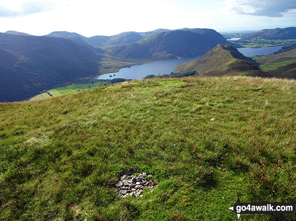
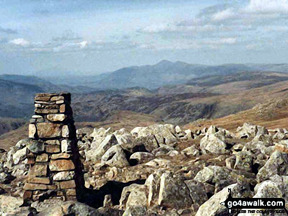
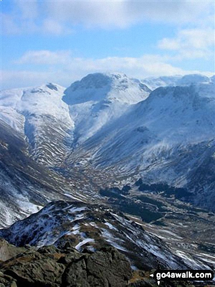
 The view from Scafell Pike in The Western Fells area of The Lake District
Photo: David Cochrane
Is there a Mountain, Peak, Top or Hill missing from the above google map or list?
Let us know an we will add it to our database.

To contribute to go4awalk.com or to contact us about anything at all - see Talk To Us.
For help see Help.
go4awalk.com and go4awalk.co.uk are registered trademarks of TMDH Limited.
Copyright © 2000-2025 TMDH Limited. All rights reserved.
Copyright Terms & Conditions Privacy Statement
A - Z Walks Home Log On/Accounts Photo Gallery Walk Ideas and Collections Fell Facts Hill Skills Walking Questions and Answers Your Stories News Competitions Product Reviews/Gear Tests Walking Gear Guides Peaks and Mountains Peak Bagging Find New Walking Friends Camping GPS Waypoints for Walking Contents Walk Search Talk To Us go4awalk.com Help Free Example Walks Newsletter


