Transits when Navigating'; = '
Q. Hello. I was wondering if you could send me some more information on the explanation on transits as I do not quite understand the definition given on your web site. This would be very helpful.
Thank you for your time.
Regards
Kirsty DeKeyzer
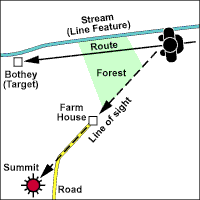
A. Transits are simply a way of finding out where you are on a long featureless 'line feature' (like a stream or the edge of a wood) and therefore how far away you are from your target (i.e. a bothy).
When two identifiable features on the map are both visible on the same line of sight they are said to be in 'Transit'. If you are walking along a Line Feature (like a stream) and you can see two identifiable features in Transit - then a line drawn on the map through the two features and back to your Line Feature (stream) will give you your position on your Line Feature (stream). The line of a road, the edge of a forest or a field boundary wall can provide the same information. Hope this helps Mike (Editor) |
 |
Add your answer to THIS question | Ask a NEW walking and hiking question
Return to the main list of Walking and Hiking Questions
Search for an existing Walking and Hiking Question or Answer


