All the Mountains, Peaks, Tops and Hills in The Shropshire Hills on a detailed list
The Shropshire Hills are located in Central England covering the south western part of Shropshire.
If you include all the Deweys, the Marilyns, the Bridgets (Hills) and all the Mountains, Tops, Peaks and Hills with a Trig Point on them there are 71 tops to climb, bag & conquer and the highest point is Brown Clee Hill (Abdon Burf) at 540m (1,772ft).
To see all Mountains, Peaks, Tops and Hills displayed in different ways - see the options in the left-hand column and towards the bottom of this page.
![]() Your Personal Bagging Record for The Shropshire Hills,
Your Personal Bagging Record for The Shropshire Hills,
LOG ON and RELOAD this page to show which Mountains, Peaks, Tops and Hills you have already climbed, bagged & conquered in The Shropshire Hills, - and which ones you have yet to visit. Furthermore, since you can also access your Personal Mountain & Hill Bagging Record via go4awalk Mobile you can quickly & easily record, edit and view your achievements - whether you are at home/work on your desktop computer or in the pub/at the top of a mountain with your Mobile Phone. (You can even download your Personal Mountain & Hill Bagging Record as a .csv file for importing into and saving with spreadsheet software like Excel or NeoOffice!) [ . . . less]
See this list in: Alphabetical Order
| Height Order‡
To reverse the order select the link again.
Mountain, Peak, Top or Hill:
Bagged

![]()
31. Clun Hill
394m (1,293ft)
Clun Hill is on interactive maps:
Clun Hill is on Peak Bagging Map and Hill Tick List: |
![]()
32. Sunnyhill
393m (1,289ft)
Sunnyhill is on interactive maps:
Sunnyhill is on Peak Bagging Map and Hill Tick List: |
![]()
33. Shelve Hill
381m (1,250ft)
Shelve Hill is on interactive maps:
Shelve Hill is on Peak Bagging Map and Hill Tick List: |
![]()
34. The Lawley
377m (1,237ft)
The Lawley is on interactive maps:
The Lawley is on Peak Bagging Map and Hill Tick List: |
![]()
35. Nick Knolls
374m (1,227ft)
Nick Knolls is on interactive maps:
Nick Knolls is on Peak Bagging Map and Hill Tick List: |
![]()
36. Switchback Hill
373m (1,224ft)
Switchback Hill is on interactive maps:
Switchback Hill is on Peak Bagging Map and Hill Tick List: |
![]()
37. Graig Hill
371m (1,217ft)
Graig Hill is on interactive maps:
|
![]()
38. Mucklewick Hill
371m (1,217ft)
Mucklewick Hill is on interactive maps:
Mucklewick Hill is on Peak Bagging Map and Hill Tick List: |
![]()
39. Adstone Hill
369m (1,211ft)
Adstone Hill is on interactive maps:
Adstone Hill is on Peak Bagging Map and Hill Tick List: |
![]()
40. Steppleknoll
365m (1,197ft)
Steppleknoll is on interactive maps:
Steppleknoll is on Peak Bagging Map and Hill Tick List: |
![]()
41. Lordshill
364m (1,194ft)
Lordshill is on interactive maps:
Lordshill is on Peak Bagging Map and Hill Tick List: |
![]()
42. Bucknell Hill
361m (1,184ft)
Bucknell Hill is on interactive maps:
Bucknell Hill is on Peak Bagging Map and Hill Tick List: |

![]()
43. Burrow (Shropshire)
358m (1,174ft)
Burrow (Shropshire) is on interactive maps:
Burrow (Shropshire) is on Peak Bagging Map and Hill Tick List: |

![]()
44. Hazler Hill
347m (1,138ft)
Hazler Hill is on interactive maps:
Hazler Hill is on Peak Bagging Map and Hill Tick List: |
![]()
45. Buxton Wood
345m (1,132ft)
Buxton Wood is on interactive maps:
Buxton Wood is on Peak Bagging Map and Hill Tick List: |
![]()
46. Helmeth Hill
344m (1,129ft)
Helmeth Hill is on interactive maps:
Helmeth Hill is on Peak Bagging Map and Hill Tick List: |

![]()
47. Callow Hill (Little Stretton)
336m (1,102ft)
Callow Hill (Little Stretton) is on interactive maps:
Callow Hill (Little Stretton) is on Peak Bagging Map and Hill Tick List: |
![]()
48. Huglith Hill
328m (1,076ft)
Huglith Hill is on interactive maps:
Huglith Hill is on Peak Bagging Map and Hill Tick List: |
![]()
49. Radnor Wood
325m (1,066ft)
Radnor Wood is on interactive maps:
Radnor Wood is on Peak Bagging Map and Hill Tick List: |
![]()
50. Little London (Middlehope Hill)
324m (1,063ft)
Send it in and we'll publish it here.
Little London (Middlehope Hill) is on interactive maps:
Little London (Middlehope Hill) is on Peak Bagging Map and Hill Tick List: |
![]()
51. Wart Hill
324m (1,063ft)
Wart Hill is on interactive maps:
Wart Hill is on Peak Bagging Map and Hill Tick List: |
![]()
52. View Edge (Weo Edge)
321m (1,054ft)
View Edge (Weo Edge) is on interactive maps:
View Edge (Weo Edge) is on Peak Bagging Map and Hill Tick List: |
![]()
53. Earl's Hill
320m (1,050ft)
Earl's Hill is on interactive maps:
Earl's Hill is on Peak Bagging Map and Hill Tick List: |
![]()
54. Diddlebury Common
317m (1,040ft)
Diddlebury Common is on interactive maps:
|
![]()
55. Short Wood
313m (1,027ft)
Short Wood is on interactive maps:
Short Wood is on Peak Bagging Map and Hill Tick List: |
![]()
56. Oakeley Mynd
309m (1,014ft)
Oakeley Mynd is on interactive maps:
|
![]()
57. Nover's Hill
305m (1,001ft)
Nover's Hill is on interactive maps:
Nover's Hill is on Peak Bagging Map and Hill Tick List: |
![]()
58. Clunbury Hill
304m (997ft)
Clunbury Hill is on interactive maps:
|
![]()
59. Lodge Hill (Causeway Wood)
304m (997ft)
Send it in and we'll publish it here.
Lodge Hill (Causeway Wood) is on interactive maps:
Lodge Hill (Causeway Wood) is on Peak Bagging Map and Hill Tick List: |
![]()
60. Pole Wood
302m (991ft)
Pole Wood is on interactive maps:
Pole Wood is on Peak Bagging Map and Hill Tick List: |
View all 71 Mountains, Peaks, Tops and Hills in The Shropshire Hills, :
- On a Downloadable PDF you can Print or Save to your Phone#
- On an Interactive Google Map (loads faster)
- On an Interactive Google Map with a list of tops below it (makes it easier to locate a particular top)
- On a Detailed List in:
Alphabetical Order | Height Order - On one page with 'yet-to-be-bagged' listed 1st & then 'already-bagged' tops listed 2nd in:
Alphabetical Order | Height Order (must be logged on) - On one page with 'already-bagged' tops listed 1st & then 'yet-to-be-bagged' tops listed 2nd in:
Alphabetical Order | Height Order (must be logged on)
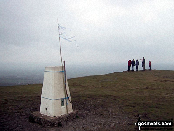
 The summit of Brown Clee Hill (Abdon Burf) in The Shropshire Hills
Photo: Bruce McDowell
# Whether you print a copy or download it to your phone, this Peak Baggers' Map will prove incredibly useful if you want to know what's what when you are up in the mountains and cannot get a phone signal
Is there a Mountain, Peak, Top or Hill missing from the above google map or list?
Let us know an we will add it to our database.

To contribute to go4awalk.com or to contact us about anything at all - see Talk To Us.
For help see Help.
go4awalk.com and go4awalk.co.uk are registered trademarks of TMDH Limited.
Copyright © 2000-2025 TMDH Limited. All rights reserved.
Copyright Terms & Conditions Privacy Statement
A - Z Walks Home Log On/Accounts Photo Gallery Walk Ideas and Collections Fell Facts Hill Skills Walking Questions and Answers Your Stories News Competitions Product Reviews/Gear Tests Walking Gear Guides Peaks and Mountains Peak Bagging Find New Walking Friends Camping GPS Waypoints for Walking Contents Walk Search Talk To Us go4awalk.com Help Free Example Walks Newsletter


